


On July 20, 1998, the city council of East Palo Alto met to consider a proposal that had been advanced in various forms for over ten years. The proposal, to demolish the city’s primary retail district and to build in its place a five-star hotel and 451,000 square feet of class-A office space, had drawn over thirty speakers to offer public comments at the meeting, most of them speaking in favor of the project, although at least one business tenant and one residential tenant living in the project area spoke passionately of the displacement they were facing. At the end of a long evening, before voting their unanimous approval to move forward with the project, the city council members spoke, followed by the city’s mayor, R. B. Jones.[1] He voiced his wholehearted support for the project and angrily denounced nearby communities that had opposed the project or had failed to offer support. “How dare Stanford University is not here tonight to support this project.…How dare Santa Clara, Mountain View, and Sunnyvale are not here.” Jones, an African American (like four of the five council members), compared opposition to the project to slaveholding and called such opposition “racism in its worst form.” [2]
Skeptical observers might dismiss this as posturing, but to understand the remark’s significance requires understanding the complex history of East Palo Alto and its retail district, Whiskey Gulch. The mayor’s remarks reflect the long history of tense relations between East Palo Alto, a low-income, majority-minority city, and its wealthier, majority-white neighbors in the Silicon Valley suburbs of the San Francisco peninsula. Both Palo Alto and Menlo Park had sued to block the Whiskey Gulch redevelopment over homeowners’ concerns about parking, traffic, and visual scale, and Menlo Park’s threat to block the project in court yet again formed the immediate context for the mayor’s remarks. But the comments signified a much longer history as well: the tensions between East Palo Alto and its neighboring cities dated back decades, at least to the formation of “Whiskey Gulch” itself.
The mayor’s remarks, and the decision they helped to justify, indicate some of the drastic changes, as well as important continuities, in the politics of urban redevelopment over the course of the previous half century. In the 1950s and ’60s, urban-redevelopment policies at the federal and state level became notorious for their displacement of low-income populations, particularly people of color, in the course of constructing new residential towers, office buildings, hotels, stadiums, hospitals, and university facilities. The racial bias inherent in urban renewal led many to dub it “negro removal,” and in the 1960s and ’70s these projects became magnets for protest movements in cities throughout the United States. Indeed, some residents of East Palo Alto itself settled there after being displaced from their previous homes by redevelopment in the Western Addition neighborhood of San Francisco.[3]
The redevelopment of Whiskey Gulch by a black-dominated city council, in the face of opposition from wealthy, white property owners, could be called a historical irony, but it was much more than that. It calls into question conventional narratives of urban-renewal history, reminding us that urban renewal did not end with the termination of federal funding for it in 1974 and in fact gained a new importance for cities in the 1980s and ’90s. It also shifts our attention away from the large, East Coast, majority-white cities that have been the focus of most previous studies of urban redevelopment and highlights the growing importance of smaller, suburban, Sun Belt, and majority-minority cities.
East Palo Alto’s redevelopment of Whiskey Gulch was a poignant indicator of the dilemmas that such cities face and the limited options they must choose from as they navigate pressures at local, regional, national, and international scales. The outcome of this redevelopment, I believe, was paradoxical: the city gave up a historic strip of minority-owned businesses in order to ensure the continued independent existence of a majority-minority city. Understanding the full significance of this trade-off requires a close reading of the local meanings of Whiskey Gulch. For some it was a haven for crime and violence, a marketplace for alcohol, sex, and drugs, and a symbol of East Palo Alto’s exploitation by surrounding communities. For others it was an ethnically diverse and socially vibrant community resource, as well as a site of crucial community services and innovative social enterprises.
The decision to replace Whiskey Gulch with the tony University Circle development illustrates French social theorist Henri Lefebvre’s insight that space is not merely a neutral medium or an empty vessel. Rather, space is a social product, constantly being created and shaped by its society, and shaping that society in turn.[4] Or, as geographer Doreen Massey puts it, “the spatial is socially constituted,” and “the social is necessarily spatially constituted too.”[5] In the case of East Palo Alto’s Whiskey Gulch, the space was shaped by forces that included highway construction, racial segregation, and political fragmentation. Over time, Whiskey Gulch became a potent symbol, shaping in turn the attitudes and identities of both East Palo Alto residents and outsiders. The redevelopment of Whiskey Gulch into law offices and an upscale hotel illustrates how state power and global capitalism produce “abstract” space—Lefebvre’s term for a space valued for money, a space of prohibition, a space “founded on the vast network of banks, business centres, and major productive entities, but also on motorways, airports, and information lattices.”[6] But the redevelopment also showed that space is produced, not through some automatic or inevitable process, but rather through contingent and, in many cases, local decisions that are shaped by lived experience and cultural representations. The transformation of Whiskey Gulch grew out of the mental maps that residents and others created of the strip, and of East Palo Alto as a whole. In Lefebvre’s terms, grasping the changes in East Palo Alto requires looking at Whiskey Gulch as representational space, “space as directly lived through its associated images and symbols.”[7]
From this standpoint, some saw the end of Whiskey Gulch as a welcome opportunity to rewrite East Palo Alto’s narrative of financial dependence, underdevelopment, and stigmatization by its neighbors and to rebrand it as “a city on the move.” Others feared that the construction of a luxury hotel and law-firm offices meant that the spatial inequalities that had long marked the boundaries between East Palo Alto and its neighbors were now going to find a place within East Palo Alto itself.
My goal in this article is not to praise or condemn the decisions made in the redevelopment of Whiskey Gulch but to explore the reasons behind the city’s trade-off and its implications for our understanding of urban development. East Palo Alto’s choice raises profound questions about the significance of space and its relationship to inequality in the emerging cities of the twenty-first century.
The legal and financial instrument that East Palo Alto used to eliminate Whiskey Gulch had a long, complex relationship to spatial inequality. Redevelopment was a powerful and flexible tool that cities used for decades to draw in private capital, often for large-scale projects that private investors would be unwilling or unable to take on alone. Redevelopment laws became widespread in the 1940s as a means to encourage reinvestment and eliminate “blight” in cities following the years of disinvestment during the Depression and the Second World War; California passed its Community Redevelopment Act in 1945. These state redevelopment statutes authorized cities to form redevelopment agencies, public bodies with powers to acquire property through eminent domain, develop that property (though not to build buildings), sell the property to private developers, and finance their operations by borrowing from federal and state governments and by floating bonds. Redevelopment agencies were also given the authority, as well as the obligation, to relocate the people previously present on the land. In the 1950s California’s redevelopment agencies were given the authority to use tax increment financing, meaning that if a redeveloped property increased in value, the redevelopment authority could keep the increased property tax receipts over the life of the project—usually some forty years.
While redevelopment was initially promoted as a means to improve urban housing and eliminate slums, it quickly became a tool for a wide range of other municipal purposes. In the fragmented and unevenly developed landscapes typical of American metropolitan areas, competition between cities and pressure from property owners turned cities into what Harvey Molotch has called “growth machines.”[8] They strive to raise property values, both to benefit owners and to fill city coffers. Redevelopment became a key for many city governments in this quest for growth, particularly after the passage of Proposition 13 in 1978 left California cities in very tight financial straits. Redevelopment always had vocal critics, however: libertarians saw it as undue interference in the free market, community advocates objected to its destruction of low-income neighborhoods, and fiscal conservatives resented its diversion of tax revenues. To help close a state budget gap, California abolished redevelopment agencies in 2012, marking the end of an era for municipal officials who had relied on urban redevelopment since the 1940s as a means of drawing private capital into cities. This is thus a fitting moment to look back and examine how those redevelopment policies helped to produce California’s spatial and racial landscape.
East Palo Alto may seem like an unlikely case study to understand the recent history of urban redevelopment, in light of its small size (under 30,000 people in 2.6 square miles) and its suburban location. Yet these traits make it all the more emblematic, both of redevelopment in California and of larger trends in metropolitan America. While urban redevelopment began in large cities, by 2011 redevelopment agencies existed in 390 of California’s 481 cities, ranging from places as large as Los Angeles, San Diego, and San Jose to those as small as Dinuba (population 21,453), Shafter (16,988), and Gonzales (8,187). Altogether, 211 California cities with populations under 50,000 had active redevelopment agencies in fiscal year 2010–11, more than two-thirds of the 311 cities in that population class.[9]
East Palo Alto is also representative of the growing diversity of America’s suburbs, which scholars have gradually begun to recognize in recent years. While early scholars of suburbs emphasized their white racial homogeneity, middle-class economic character, and exclusively residential land use, a second wave of suburban scholars has examined the more diverse reality, including black suburbs, working-class suburbs, and industrial suburbs.[10] Historians now know that suburbs have long housed a variety of races, classes, and land uses, and current scholarship confirms that this diversity continues to grow, with the 2010 census revealing that suburbs host increasing numbers of people of color, immigrants, and people living in poverty.[11]
In this context, East Palo Alto exemplifies changing notions of suburban identity, particularly when seen in relationship to its more affluent neighbors. East Palo Alto’s Latino population has grown from 36.4 percent of the city’s total in 1990 to 64 percent in 2010, while its African American population has fallen from 41.4 to 16 percent in the same period. Over the same two decades, its white population has fallen from 12.1 to 6 percent, and its Asian and Pacific Islander population has risen from 9.2 to 11 percent. Meanwhile, the adjoining community of Palo Alto has gone from 5 to 6.2 percent Latino, and from 2.9 to 1.9 percent black. It has remained predominantly white, although its white majority has dropped from 84.9 to 64.2 percent, while it has gained a large Asian minority, which has grown from 10.4 to 27 percent. Suburban racial change is ubiquitous, whether in affluent suburbs such as Palo Alto (whose poverty rate from 2008 to 2012 was 4.9 percent) or poorer suburbs such as East Palo Alto (whose poverty rate was 18.0 percent during that period). But communities such as East Palo Alto have been in the vanguard; as Albert Camarillo has argued, cities of color, particularly small cities such as East Palo Alto, are the “new racial frontier” in California and in the United States.[12]
In light of rising metropolitan diversity, addressing uneven development between and within suburbs has become just as important as earlier efforts to address inequalities between suburbs and their central cities, a point made by a cohort of scholars and activists arguing for “regional equity.”[13] The (re)development of East Palo Alto offers an opportunity to view the structural forces at many scales that affect (and often undermine) regional equity: regional labor and real estate markets, state redevelopment and tax law, national transportation and taxation policies, and global flows of capital and population. East Palo Alto’s location in the heart of Silicon Valley, a region known for its uneven development, adds to its value as a case study.[14]
Separate and Unequal: The Underdevelopment of East Palo Alto
East Palo Alto is located in San Mateo County, across the county line from Palo Alto, which is situated in Santa Clara County. Prior to East Palo Alto’s incorporation in 1983, the area encompassed by the city’s boundaries today was an unincorporated area. Graced with a favorable location on the San Francisco Bay approximately halfway between San Francisco and San Jose, the area was a hub in the nineteenth century for both water and rail transport. In the early twentieth century, the area was home to the Weeks Poultry Colony, a utopian cooperative agricultural settlement.[15]
Although the poultry colony failed during the Depression, the area continued to attract agricultural activity, including Japanese and Italian immigrants who cultivated flowers. As in many cities in the Bay Area and elsewhere, the internment of the Japanese during the Second World War provided an opening for African American migrants drawn to the area in search of wartime work, in need of housing, and excluded from many other residential areas by restrictive covenants, racial steering, and redlining.
The postwar period marked a growing divergence between East Palo Alto and many of its neighbors both racially and economically. Until this time, the agricultural economy of East Palo Alto, together with low-density residence and small-scale industry, was typical of many other towns on the San Francisco peninsula. In the wake of the Second World War, however, many of the Bay Area’s formerly unincorporated areas were incorporated independently or annexed to existing cities. This incorporation process enabled white homeowners to defend their property values by controlling property tax rates, land use, municipal services, and the legal barriers that kept “undesirable” populations out. These newly incorporated cities (such as Milpitas, incorporated in 1954, and Fremont, in 1956) attracted investment from private industry and developers and, more significantly, from the federal government via Federal Housing Administration–backed mortgages as well as military contracting. During this time of intensifying development in the region, East Palo Alto’s unincorporated status and racially diverse population effectively excluded it from the sources of development capital.[16]
While East Palo Alto’s neighboring towns of Palo Alto and Menlo Park saw their landscapes developed into the high-tech office parks, “clean” manufacturing facilities, and upscale suburbs that constitute “Silicon Valley,” nonincorporation in East Palo Alto attracted land uses and residents that were shut out by the rules, such as municipal zoning ordinances or racial covenants, that governed incorporated space. Unlike incorporated communities, East Palo Alto did not control its land use; those decisions were made by San Mateo County. The East Palo Alto area thus found itself saddled with an increasing number of locally unwanted land uses (LULUs), including a chemical waste treatment facility and a county landfill. It also could not stop state highway planners from bisecting it with the Bayshore Freeway, which had cut through the community in the early 1930s and was widened some three decades later.
As East Palo Alto became more isolated economically from the investment boom taking place around the Bay Area and more subject to a disproportionate environmental burden, it also (and not coincidentally) became increasingly differentiated demographically and cut off spatially. Demographically, the population of what is now East Palo Alto went from 72 percent white in 1960 to 61 percent black in 1970, and the area became an important center for African American culture and politics in the Bay Area.[17] Local activists inspired by anticolonial ideologies began to refer to the area as “Nairobi” and to establish Afrocentric institutions, including a small independent school that included kindergarten through college-level students.
Spatially, East Palo Alto’s isolation increased as surrounding cities began to carve away at the unincorporated areas of San Mateo County, selectively annexing valuable pieces of land into the cities of Menlo Park and Palo Alto. Palo Alto (through a land swap that enabled it to annex land across the county line) annexed its airport from the unincorporated land near the bay, while Menlo Park annexed parts of the Belle Haven and Newbridge neighborhoods, including the offices of Hillier Aircraft.[18] The Bayshore Freeway was widened with federal and state funds and was designated California Highway 101 in the mid-1960s. The new, wider highway not only cut off East Palo Alto from its neighbors but also divided the community internally, isolating the westernmost portion, which included the strip of bars, liquor stores, retail outlets, and nonprofit offices known as Whiskey Gulch. As Raymond Mohl and other scholars have shown, highway routes were planned at the state level by transportation officials who gave little heed to the social damage caused when communities were divided by a road, and who often had the specific intention of forming spatial barriers between areas of white and black settlement.[19] Highway 101 formed a barrier between the middle-class, majority-white community of Palo Alto and the poorer, more racially diverse community on the other side of the highway. Whiskey Gulch found itself, somewhat anomalously, in the small piece of East Palo Alto that remained on the Palo Alto side of the road.
Increasingly, then, the unincorporated status of East Palo Alto meant that its fate was determined at other political scales: by land use planners at the county level and by transportation and housing officials at the state and national level. The spatial inequality between unincorporated East Palo Alto and its incorporated neighbors became more pronounced, and more racially marked, over the course of the postwar period.
Producing Abstract Space: East Palo Alto’s Turn to Redevelopment
In the early 1980s a group of East Palo Alto activists organized and led a campaign urging community residents to incorporate East Palo Alto. After a narrow loss in 1982, incorporation proponents resubmitted the question to a vote in 1983 and succeeded by a margin of fifteen votes. Opponents, who feared that incorporation would bring a rise in taxes and a drop in services, challenged the result, citing irregularities with absentee ballots. A series of appeals led ultimately to the US Supreme Court, but when the justices declined to hear the case, a lower-court ruling in favor of incorporation was allowed to stand, creating East Palo Alto as a city.
Given the area’s history of underdevelopment and isolation, however, the new city faced an immediate difficulty: the lack of a tax base to fund the provision of basic municipal services. The early 1980s was perhaps the worst historical moment at which it could have confronted this challenge. In 1978 an anti-tax “revolt” in California led by white suburban homeowners had enacted Proposition 13, severely limiting municipalities’ ability to raise funds through property taxes. Two years later a similar anti-tax, anti-government sentiment swept Ronald Reagan into the White House, and under his administration funding for municipalities and for social programs was cut drastically. A severe recession, the outbreak of the AIDS epidemic, and the growth in popularity of crack cocaine added to the burden faced by East Palo Alto and other cities in the early 1980s.[20]
As the regional economy began to recover in the late 1980s, however, developers began to approach the city about redeveloping sections of East Palo Alto. As geographer Neil Smith has argued, reinvestment in areas previously subject to disinvestment can be explained by the “rent gap” that appears between the current value of a property and its potential value under redevelopment.[21] As East Palo Alto’s economy struggled in the midst of a built-up and prosperous region, the increasing demand for high-tech corporate offices and space for corporate-services firms drove the rent gap up significantly; by January of 1989 the press was noting that East Palo Alto was “suddenly” attractive to developers, as some half a dozen major development proposals were under discussion.[22]
In early 1987 developer Joaquin de Monet approached the city about the possibility of forming a redevelopment district to convert Whiskey Gulch from a retail district into high-end, high-rise office and hotel space. As initially presented, the development was to include two 275-foot-tall towers, making them the tallest buildings between San Francisco and Los Angeles. These would house a hotel, a ten-screen movie theater, a performing-arts center, restaurants and shops, and 341,000 square feet of office space.[23] In November 1988 East Palo Alto voters rejected a parcel tax and a utility-users tax that were on the ballot (although voters later approved the parcel tax in June 1989). Feeling the increased financial pressure, East Palo Alto’s city council, which was also the board of its redevelopment agency, responded with a preliminary decision to pursue de Monet’s plan.
East Palo Alto’s turn to redevelopment as a source of municipal revenue made sense for a number of reasons. Redevelopment had helped many cities attract capital and generate revenue since its enactment in 1945, and its potential to increase city income became more important in the wake of Proposition 13. The number of agencies statewide jumped from 159 in 1975 to 313 in 1985 as cities scrambled for new ways to raise funds in an environment characterized by geographer David Harvey as one of “heightened inter-urban competition.”[24] Redevelopment in California also became an important means of financing affordable-housing construction. In 1976, with the federal government pulling back from public-housing construction, California required redevelopment agencies to spend 20 percent of their tax increment funds on low- and moderate-income housing.[25]
The proposal to redevelop Whiskey Gulch soon ran into problems. Almost immediately, the cities of Palo Alto and Menlo Park and the Crescent Park Neighborhood Association, representing a wealthy neighborhood near Palo Alto’s border with East Palo Alto, sued to block the project. The neighboring communities cited fears of traffic volume and parking problems and the possibility that the office buildings would cast shadows on Palo Alto properties. East Palo Alto leaders were incensed by the obstructions. “It’s not unusual for a community like Palo Alto to massage their feelings of patronage and to look down on a struggling minority community, but if there’s one unifying force in EPA, it will be to stand up to Palo Alto,” East Palo Alto councilwoman Patricia Johnson told the San Jose Mercury News.[26] Some believed that quashing the project would mean the end of East Palo Alto as an independent city; rumors flew that it would be unincorporated or placed into receivership.[27]
The lawsuits forced the city and the developer to scale back the project, and a settlement was reached in 1991 with the plaintiffs. But just as the objections by the city’s neighbors were resolved, new complaints arose from within East Palo Alto. In mid-1992 a group of community activists and small-business owners in East Palo Alto filed suit to block the de Monet development, citing the lack of guarantees for local jobs, inadequate relocation assistance for tenants, and insufficient revenue for the city included in the deal. When a new coalition sympathetic to these objections was elected to the East Palo Alto City Council in November of 1992, the lead tenant of the proposed project, Adobe Systems, pulled out and the deal was scuttled.
For several years, the redevelopment proposal languished; city leaders focused on “cleaning up” Whiskey Gulch, employing community policing techniques, collaborating with a new merchants’ association, and working with federal and state law enforcement agencies to close down “social clubs” in the area that were accused of harboring illegal alcohol, gambling, drugs, and prostitution.
In 1996 East Palo Alto faced another financial crisis, brought on by a court ruling that invalidated the city’s parcel tax and ordered the city to return the millions it had collected from property owners over several years. Simultaneously, the dot-com bubble was beginning to grow, contributing to renewed activity in the Silicon Valley real estate market. East Palo Alto was once again touted as the “newest hot property” and a “developer’s dream.”[28] In early 1997 two developers expressed an interest in picking up where de Monet had left off. The city council, now solidly prodevelopment, reviewed two proposals and accepted one from Circle Partners, a group headed by Menlo Park developer Linda Law.
Law’s proposal was essentially similar to de Monet’s—it would include a 240-room hotel and 380,000 square feet of office space. To satisfy community concerns, she also proposed a job-training center and promised a $2.5 million one-time payment to the city and $2.5 million in annual retail and hotel taxes. The deal also included a target for the hotel and retail tenants in the development to hire 30 percent of their workforce from within East Palo Alto. Law’s path to completing the development proved smoother than de Monet’s, partially because of the agreements de Monet had previously forged with the neighboring communities and the residents of East Palo Alto. Menlo Park residents tried to block the development on the grounds of an inadequate environmental impact report, but the court ruled in East Palo Alto’s favor. Demolition began in April 2000; in November 2001 the developer announced that the hotel would be part of the multinational Four Seasons chain, a Canadian-based company that had half of its 26,000-person workforce outside North America.[29] By March 2002 the three Leadership in Energy and Environmental Design–certified gold-rated towers, containing 451,000 square feet of class-A office space and, according to the leasing office’s website, featuring “Brazilian granite and Italian limestone exteriors and large, dramatic water fountains in a courtyard setting,” were welcoming their first tenants.[30] Although the dot-com bust, together with some construction difficulties, enabled the developer to negotiate an $8.4 million hotel-tax rebate from the city, the hotel opened to great fanfare in January 2006. Just a few months earlier, Wells Fargo’s real estate investment trust had bought the three office buildings, whose tenants included a number of major global law firms, from the developer for a total of $306 million. East Palo Alto’s city leaders, together with the developer and investors, had clearly succeeded in producing “abstract space,” space that, in Lefebvre’s terms, “includes the ‘world of commodities’ and its ‘logic,’ and its worldwide strategies, as well as the power of money and that of the political state.”[31] Through the power of money and the state, the assessed value of the land in Whiskey Gulch went from $7.3 million in 1988 to $421.8 million in 2008–9.[32]
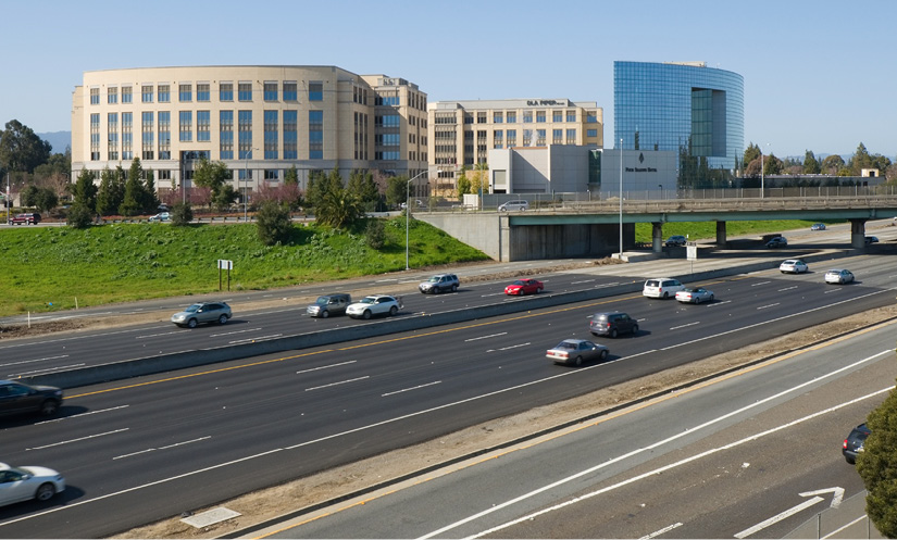
University Circle, viewed from the east side of Highway 101 in East Palo Alto, February 2013. Photo credit: LPS.1 via Wikimedia Commons. https://upload.wikimedia.org/wikipedia/commons/8/84/University_Circle_East_Palo_Alto.jpg
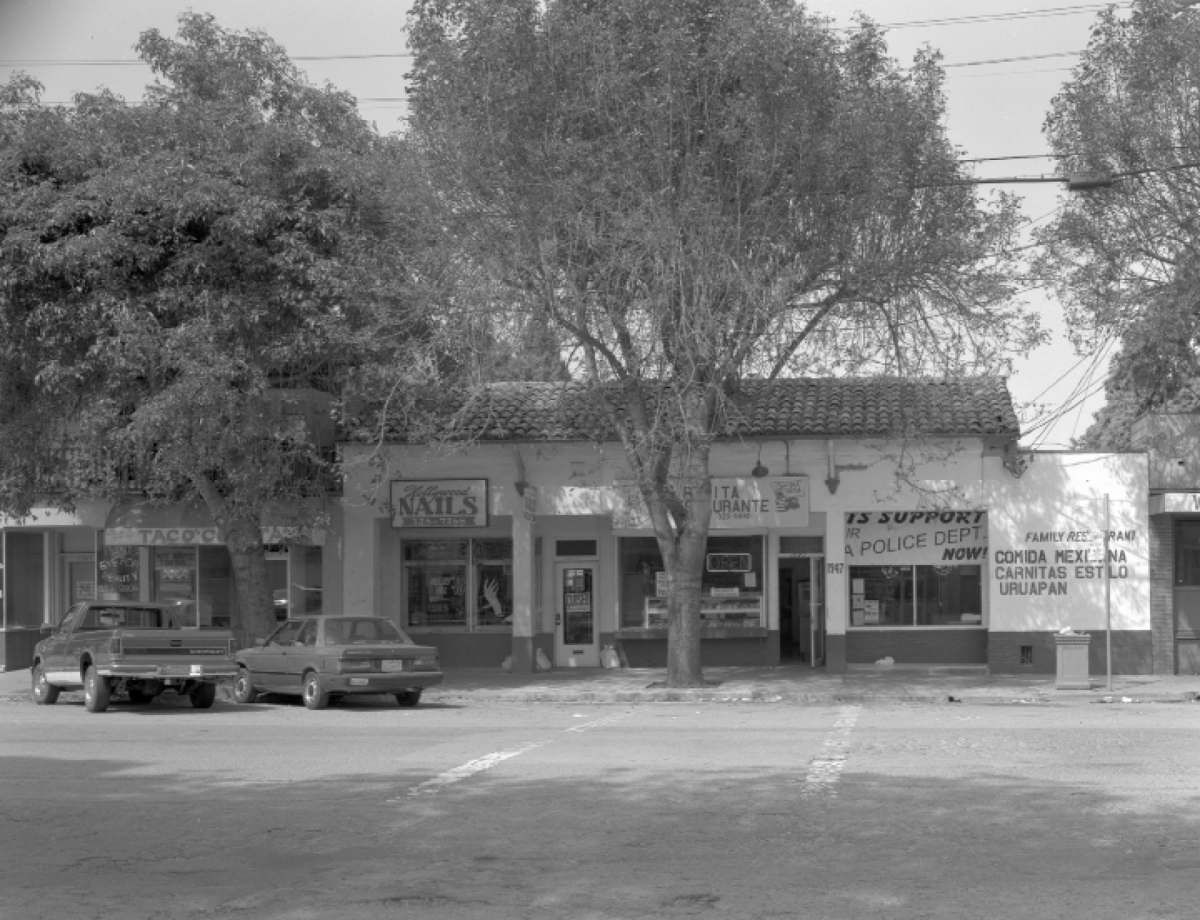
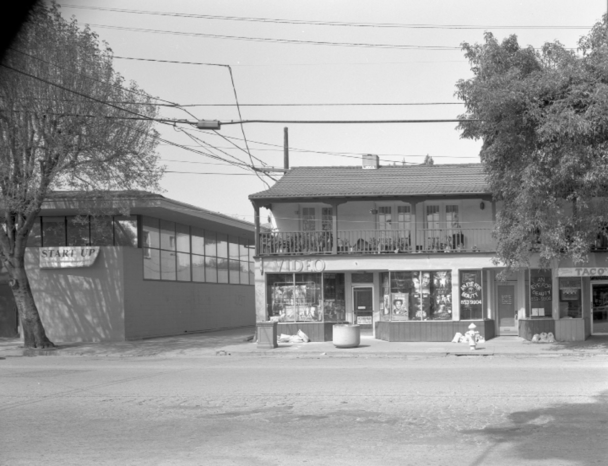
Storefronts in “Whiskey Gulch,” on University Avenue in East Palo Alto, spring 1998. The range of uses shown here includes a nonprofit, a beauty parlor, a nail salon, and several restaurants. Photographs © Mickey Shanabarger.
Representational Space: The Meanings of East Palo Alto and Whiskey Gulch
East Palo Alto’s turn to redevelopment was reasonable, even typical, given the structural constraints that it faced. But understanding how East Palo Altans came to accept, even embrace, the decision to redevelop Whiskey Gulch requires seeing what Whiskey Gulch meant to those in the community, as well as to those outside it. Whiskey Gulch was a culturally diverse environment of retail stores, food-and-drink establishments, and social service providers. It was also a multivalent symbol whose meaning was shaped in part by East Palo Alto’s racial history. Linda Law indicated the importance of the strip’s meaning when she urged the city at the July 20, 1998, hearing to “replace crime stories with success stories”—in other words, to shift the narrative of Whiskey Gulch. Understanding the area at this level requires viewing Whiskey Gulch in the social imagination of East Palo Alto residents. As historian Robert Self comments, space is socially constructed in part as “imaginative maps through which people organize and record what cities mean.”[33] In Lefebvre’s terms, this dimension of spatial experience corresponds with representational space, “space as directly lived,” including the “affective kernel” that gives space its emotional resonance.[34]
Of course, there was no single emotional meaning or imaginative map of Whiskey Gulch, given the city’s diverse and rapidly changing demographics. The best historical account of East Palo Alto’s redevelopment, Michael Berman’s Stanford master’s thesis, argues that the transformation of Whiskey Gulch attracted a broad consensus of the city’s former black majority, its new Latino majority, and its rising Asian and Pacific Islander communities. Yet it is difficult to evaluate whether the prodevelopment consensus reflected full agreement or merely the lack of an organized opposition. As Berman himself notes, “the increase in the number of Latinos and other immigrants was not accompanied by an increase in their political power in proportion to their numerical dominance.”[35] This lack of political power might explain why the voices of the displaced residential tenants, most of whom were Latino, do not appear in the recorded debates over the redevelopment of Whiskey Gulch.
At the level of social imagination and emotional meaning, Whiskey Gulch’s significance was contested, often in racially inflected terms. The name “Whiskey Gulch” suggests its meaning for many, both inside and outside the East Palo Alto community. The name connoted not only cheap liquor but also darkness, desolation, even the lawlessness of the Wild West. Its reputation in Menlo Park and Palo Alto, reported the San Jose Mercury News, was as “an unsightly high-crime blight.” “I used to avoid taking that exit when I had the kids in the car,” one woman told the Los Angeles Times.[36]
These images of crime and desolation were not racially innocent. Crime was considered one element of “blight,” a central term in the history of redevelopment that also carries a great deal of racial baggage. An area had to be declared “blighted” in order to be redeveloped; in San Francisco’s earliest redevelopment documents, the proportion of nonwhite population was included directly in the definition of “blight” and hence in the decision to redevelop a neighborhood.[37] In subsequent years, “blight” was defined in less overtly racial terms, yet for many the term remained racially tinged at the very least. As Chris Ellis, an East Palo Alto real estate agent, said, “People think that it all goes together: blight, crime, and racial composition.”[38]
For East Palo Alto’s residents of color, Whiskey Gulch and its name had a different racial significance: they recalled the ways that the community’s space was dominated and exploited by neighboring white cities and institutions, particularly Stanford University. The history of Whiskey Gulch dates back to policies that were promoted by Stanford University officials in the late nineteenth and early twentieth centuries and were intended to limit student access to alcohol. When railroad magnate and former California governor Leland Stanford and his wife, Jane Lathrop Stanford, founded the university as a memorial to their son in 1891, they simultaneously established Palo Alto as a “dry” town where alcohol sales were prohibited. University officials, however, soon found that students were traveling to nearby unincorporated areas to obtain liquor, and in 1909 they prevailed upon state legislators to create a zone of 1.5 miles around the Stanford campus in which alcohol sales would be prohibited.[39] “Whiskey Gulch” lay just beyond the borders of dry Palo Alto and outside the state-mandated buffer zone. It also lay near an exit to the increasingly busy highway, benefiting from the patronage of commuters who might stop in order to have a drink or pick up a bottle on their way to other suburban destinations. As a result, for many East Palo Alto residents, Whiskey Gulch’s reputation for crime reflected the behavior of “white outsiders coming to misbehave amid what was a mostly black community,” as resident William Webster explained.[40]
Yet there were other imaginative maps for Whiskey Gulch as well. Many East Palo Alto residents referred to the area not as “Whiskey Gulch” at all but as “Over the Ramp.” This toponym not only shifted the emphasis away from liquor and lawlessness but shifted the viewpoint from that of an outsider approaching the community in order to obtain alcohol to that of an insider living on the east side of Highway 101 and viewing Whiskey Gulch as the part of the community cut off by the freeway. Yet this designation did not necessarily suggest stronger ties to the strip; it connoted physical distance, and possibly social distance as well. The area “over the ramp,” including Whiskey Gulch and the blocks that surrounded it, was in many ways distinct from the larger portion of East Palo Alto on the other side of the freeway. The area on the Whiskey Gulch side was disproportionately white (in the 2000 census, 43.6 percent of the population on the west side of the freeway was white, compared to 27 percent in the city as a whole) and disproportionately renter occupied (84.5 percent of housing units on the west side, compared with 56.5 percent for the city as a whole).[41] As mentioned above, though, the households actually displaced by the redevelopment were predominantly Latino, at 63 percent, followed by blacks and whites, each of whom constituted 12 percent of those forced to relocate.[42]
Given the social distinctiveness of the area “over the ramp,” and the racial suspicions with which Whiskey Gulch was viewed by both whites and people of color, the decision to redevelop the area may appear obvious. Yet more positive mental maps of Whiskey Gulch also circulated. Perhaps the one with the greatest potential was Whiskey Gulch as Main Street. Many East Palo Alto residents understood that the “Whiskey Gulch” designation was a misnomer for a strip that contained a wide variety of businesses and uses. The largest category of business in Whiskey Gulch in 1998 was independent fast-food restaurants, of which there were nine. There were eight hair and “personal care services” establishments and five realty offices. There were also three cocktail lounge/bars and three liquor stores, three photography services shops, three shops dealing in “specialty apparel/jewelry/wigs,” as well as a number of stores dealing in everything from videos to records to hardware to meat.
Shops in Whiskey Gulch were small, both financially and physically. The overwhelming majority were sole proprietorships, with an average of two employees per shop. Some establishments operated in spaces as small as two to three hundred square feet; only a few, such as the independent supermarket, the meat market, and the car wash, occupied more than ten thousand square feet.[43] To many East Palo Alto residents, the strip was “a homey neighborhood shopping center” where, according to a local journalist, “merchants and customers greet one another, asking about family members or discussing which is the best kind of bird seed to buy.”[44]
Newspapers frequently commented on the presence of “ethnic” food institutions such as rib joints and taquerias, but the multiculturalism of Whiskey Gulch went well beyond menus. African Americans constituted about a third of the business owners in Whiskey Gulch; Latino owners made up 19 percent and Asian Americans 17 percent.[45] A number of the street’s institutions over the years, such as the Club Afrique nightclub and the Nairobi Cultural Arts Center, reflected East Palo Alto’s Afrocentric identity as “Nairobi.” Whiskey Gulch also included ethnic institutions representing other portions of the population, such as Pacific Islander Outreach, founded to serve the city’s growing population from Tonga and Samoa.
In addition, Whiskey Gulch was home to a rich network of nonprofit institutions and organizations, such as the Ecumenical Hunger Program, the East Palo Alto Historical and Agricultural Society, and the addiction recovery program Free at Last. A number of the area’s nonprofits represented original, entrepreneurial approaches to community needs—early exemplars of what came to be called social innovation. Plugged In, for example, was founded in 1992 to address the “digital divide” by providing computer access and training; Bill Clinton visited in April 2000 to highlight the program’s success. Plugged In helped to develop another nonprofit, Open Voice, which created and ran a popular youth-oriented website in the late 1990s.[46] Altogether there were ten nonprofits in the Whiskey Gulch neighborhood in 1998, and the density of their locations permitted unique collaborations. As local nonprofit leaders received their ninety-day relocation notices in late 1999, a journalist reported their concern that they would be unable to replace “the sense of community and collaboration that being in close proximity has allowed them to foster. Often, staff at one agency will send clients over to another for additional help.”[47]
A number of scholars have described the importance of sites that offer a meeting place and a sense of community outside home and work. Ray Oldenburg has called these “Third Places” and argues that they offer personal benefits, including friendship, perspective, and novelty, as well as social benefits, such as political discussion, ritualized revelry, and public safety. He argues that small-town main streets of the mid-twentieth century included many such third places: bars, liquor stores, drug stores, post offices, and the street itself. Such places took on additional value in Silicon Valley, a landscape marked by “a paucity of public spaces.”[48] Oldenburg’s analysis suggests that the merchants and customers in Whiskey Gulch exchanging advice about birdseed were doing more than chatting; they were building the community’s assets, increasing what Robert Putnam has termed its social capital.[49]
As the redevelopment of Whiskey Gulch approached, some urged the city to preserve this source of social capital and renovate Whiskey Gulch as the city’s “main street.” Kevin Rafter, a native of Palo Alto, opined in a letter to the San Francisco Chronicle: “There is real culture and history in Whiskey Gulch, which could help it create a niche for itself,” adding that, rather than destroy it, the city should “investigate some urban infill strategies.”[50] San Mateo County’s “Historic Resources Inventory Report” on East Palo Alto confirmed that several of the buildings were of historical interest, including the Monterey-style building at 1939–1943 University Avenue, the Spanish Colonial Revival–style building at 1945–1947 University, and the first suburban Safeway store at 1991 University. All these structures dated from the 1930s, “a period when East Palo Alto business enjoyed increased prosperity stimulated by the completion of Highway 101 and the growth in the area’s population.”[51]
Given the historical significance of these structures, it is not surprising that among the strongest proponents of a “main street” plan for Whiskey Gulch was the East Palo Alto Historical and Agricultural Society (EPA HAS). EPA HAS was much more than a typical local historical society; it was dedicated to the celebration of the community’s assets (the acronym was meant to suggest that East Palo Alto has a great deal to offer), particularly its agricultural past and the distinctive landscapes associated with that heritage. It was founded in 1990 by Trevor Burrowes, a Jamaican American activist and artist who sought to preserve the “large home lots, historic buildings, open space and farming enterprises” in East Palo Alto’s Weeks neighborhood from the “Silicon Valley development boom.” Together with the National Park Service and the nonprofit planning firm Urban Ecology, in 1997 EPA HAS produced the “Weeks Neighborhood Plan,” a comprehensive plan for land use, traffic, economic development, and historic preservation in the land formerly occupied by the Weeks Poultry Colony. The plan also served as a visionary critique of the “growth machine” mentality that led to neighborhoods being “developed, one lot at a time, for maximum profit.” The Weeks plan urged a socially and environmentally sustainable future for East Palo Alto based on the preservation of agriculture and open space rather than the constant proliferation of freeways, subdivisions, and shopping centers.[52]
The executive director of EPA HAS, Stephenie Smith, brought this skepticism about untrammeled growth to bear on the plans for Whiskey Gulch. She asserted that Whiskey Gulch was “a historic district, eligible for the national historic registry,” and advocated a “Main Street” plan that would gradually redevelop the street and preserve its primarily retail character.[53] At the July 20, 1998, hearing this plan was presented by consultants Lindsay Davidson and Bill Kennedy, who asserted that “there is [sic] very legitimate social, cultural and historical needs currently being met by University Avenue.” The city council, however, did not share this mental map. Council member Sharifa Wilson said the idea had already been studied and dismissed as infeasible; council member Duane Bay told the Main Street proponents that they were years too late. Both expressed their commitment to retaining a retail hub for the community, but as Wilson said, “the shopping will be done on the other side of the freeway.”[54]
The mental map of Whiskey Gulch as “main street” was thus not influential enough to change the city’s development plans. Two other images proved to have greater cultural and political influence; both were images of East Palo Alto as a whole, with implications that echoed in the depictions of Whiskey Gulch. The first was East Palo Alto’s designation as the nation’s “murder capital” in 1992. With forty-two homicides recorded that year, East Palo Alto led US cities in the number of killings per capita. Sensational and repeated media coverage of this violence attached to the city a stigma in the media that, much to residents’ chagrin, has proven very difficult to erase.
The violence of 1992 became associated with Whiskey Gulch in ways both real and symbolic. In February, Palo Alto lent four police officers to East Palo Alto and had them patrolling in Whiskey Gulch; after a week, Palo Alto’s police chief reported: “Almost every night, bullets have been fired and other violent acts committed.”[55] Some nearby Menlo Park residents were so worried that they proposed installing barriers to physically prevent traffic from flowing between their neighborhood and the Whiskey Gulch section of East Palo Alto—an idea that came back up when the University Circle project was nearing final approval in 1998.[56]
The crime wave of 1992 was instrumental in moving the East Palo Alto City Council toward a consensus on redevelopment. As Michael Berman recounts in his master’s thesis on East Palo Alto’s ethnic politics, the high murder rate led the council to hold a retreat shortly after the fall 1992 elections. At this retreat they vowed to put aside differences that had divided previous councils and to move forward for the common good. “In many ways, this commitment to political cooperation served as the foundation for a community-wide consensus that crossed ethnic and racial lines that redevelopment was necessary for the growth if not survival of East Palo Alto.”[57] Thus, years before Linda Law urged the council to “replace crime stories with success stories,” the narratives of crime and redevelopment were linked in the community’s image of Whiskey Gulch.
As important as the “murder capital” image was for defining Whiskey Gulch in the social imagination, its counterpart, emphasizing the city’s bright future, was just as significant. The narrative of progress, embodied in the image of East Palo Alto as “a city on the move,” played an essential role in justifying the redevelopment. Mayor Sharifa Wilson emphasized the phrase, East Palo Alto’s unofficial slogan, in her state of the city address in 1993 as she urged the city to turn away from the past and to move forward with economic development. A large, handwritten sign bearing the phrase hung over the city council chambers during the decisive meeting of July 20, 1998.
In contrast to the effort to portray East Palo Alto as a forward-looking, future-oriented city, Whiskey Gulch was depicted as antiquated and backward. “Driving through Whiskey Gulch … is like blasting through a time warp,” reported the San Francisco Chronicle in 1997. “While the rest of Silicon Valley has prospered, Whiskey Gulch looks much as it did in the 1940s and ’50s.”[58] Other observers similarly emphasized the contrast between the fast-paced valley with its global corporations and the slow-paced, small-scale businesses of Whiskey Gulch. “I will miss the small-town feel of Whiskey Gulch,” wrote Loretta Green. “But that is not the way of this valley, nor, I fear, the future world.” [59] Many of those who favored the project, including many Whiskey Gulch business owners themselves, spoke of the need for, and the inevitability of, “progress,” a term that connoted everything from improved city services to rising property values, to more highly capitalized firms, to a sleeker and more uniform landscape. The belief in its inevitability became a self-fulfilling prophecy. Whiskey Gulch was located in both a city and a region that saw progress as key to their prosperity, and this fact, perhaps more than any other, determined the mental map of Whiskey Gulch in East Palo Alto’s social imagination. When Linda Law promised that “the future would be a radical departure” from Whiskey Gulch’s past, she appealed to a very powerful desire on the part of many both in and out of East Palo Alto: to transform Whiskey Gulch as representational space.[60]
Conclusion: The Legacy of Redevelopment
The fiscal and structural constraints that East Palo Alto faced in the 1990s made redevelopment a logical step to preserve the city’s independent existence; the rent gap in Whiskey Gulch made it a site for redevelopment; and the desire to turn away from the city’s image as the “murder capital” and to place it instead on the cultural map as “a city on the move” made the redevelopment appealing or, at the very least, acceptable to most East Palo Altans and the unanimous city council. The structural forces producing abstract space and the racial narratives shaping representational space both played a role in the city’s redevelopment decision, which ultimately met relatively little public resistance.
Redevelopment transformed Whiskey Gulch from a low-value, low-rent retail district featuring small proprietorships serving a local clientele into a high-end office and hotel complex featuring highly capitalized businesses that compete in the global marketplace. Tenants in the office towers include major law, financial services, and venture capital firms. University Circle is a space of global capital par excellence.
Financially, the project was a stunning success: in addition to the more than fiftyfold increase in assessed land value, the project generates $2 million to $3 million annually in transient occupancy (hotel) taxes and has helped the city increase its annual operating budget from $6.8 million in 1992 (of which 12 percent came from foundation and federal grants) to $15.23 million in 2009 (of which less than 1 percent came from grants).[61] The complex has been somewhat less successful in generating jobs for the city. Despite the goal of employing a workforce composed of 30 percent East Palo Alto residents, the Four Seasons managed only 15–16 percent throughout most of 2011 (the most recent year for which figures are available) and fell to a dismal 7 percent in the fourth quarter. (It should be noted, though, that in East Palo Alto’s other redevelopment project, the Gateway 101 retail center, the hiring goals have generally been met or exceeded, so that when taken as a whole, the hiring figures in the city’s redevelopment businesses averaged between 36 and 39 percent in 2011.)[62]
While the gains that have come from redeveloping Whiskey Gulch are easy to enumerate, the losses—of community, of social capital, of public space, of social services—are harder to quantify. Several local artists have expressed their sense of loss, looking back at Whiskey Gulch with apparent fondness, even nostalgia, an emotion that geographer Yi-Fu Tuan defines as an evocation of “an idealized and stable past.”[63] Z’ma Wyatt, a photographer born and raised in East Palo Alto, created an exhibit of photographs and newspaper clippings to “soften her grief” at the loss of Whiskey Gulch and Ravenswood High School.[64] Filmmaker Michael Levin created a short film, The Last Days of Whiskey Gulch, which features cinema verité–style depictions of daily interactions in Whiskey Gulch interspersed with interviews of businesspeople, customers, and politicians in East Palo Alto during the days in early 2000 before the strip was razed. Explaining why she feels “sentimental” about leaving Whiskey Gulch, wig store owner Won Choi explains, “It’s not just business and money. It’s people, actually.”[65]
The social production of space through redevelopment in California thus did not end with the collapse of federal urban-renewal funding in 1974; it endured up to the early twenty-first century, reshaping increasing numbers of small cities and suburban cities such as East Palo Alto. In early 2012, however, redevelopment in California came to an end when the governor abolished redevelopment agencies to help close the state’s budget deficit.[66] This decision left East Palo Alto facing a dilemma. Having demolished the closest thing it had had to a downtown, the city was planning to use its redevelopment authority to create a new town center on the east side of the freeway. With input from the community, the city created a plan for a mixed-use, transit-oriented, “smart-growth” development with 115 residential units and 16,000 square feet of neighborhood-serving retail.[67] With redevelopment’s abolition, the city was left in uncertainty as to how it would finance and administer the implementation of the plan.
The redevelopment of Whiskey Gulch into University Circle is a vivid reminder that the social production of space is determined at multiple scales: by the investment strategies of global corporations, the policies of federal, state, and municipal governments, and the narratives of time and place that circulate within local communities. This redevelopment has left an ambiguous legacy in East Palo Alto. As the mayor’s remarks at the hearing in July 1998 suggested, the redevelopment provided East Palo Alto with an opportunity to act without the support of its neighbors, laying a foundation of greater municipal self-determination and financial independence. At the same time, the redevelopment meant a loss of communal space and increased domination of the city’s landscape by global capital. My point is not to mourn the loss of Whiskey Gulch; whatever its vices and virtues were, Doreen Massey urges us to reject nostalgia as a fruitless effort to impose a fixed meaning on a place that is inherently porous and unbounded.[68] Indeed, the current residents of East Palo Alto are more interested in creating a new public space for their town than in memorializing or restoring the past. Redevelopment’s repeal, however, leaves the city’s government, and hundreds like it, facing a future in which their powers to influence spatial production are less certain, while the structural constraints confronting them remain as daunting as ever. 
Michael B. Kahan is the associate director of the Program on Urban Studies at Stanford University. His interest in the historical transformation of urban space has led to publications on topics including the integration of streetcars in the 1850s, sanitation reform in the 1890s, and the geography of prostitution in the 1910s. He holds a BA from Yale and a PhD in history from the University of Pennsylvania.
-
In East Palo Alto, as in many small California cities, the position of mayor is largely ceremonial and nonpartisan and rotates among elected members of the city council. The daily administration of the city is carried out by an appointed city manager. ↩
-
Video recording of hearing, in possession of author. I am grateful to Michael Levin for providing me with this document. ↩
-
The literature on urban renewal and redevelopment is extensive. Among important early critics of the policy, see Jane Jacobs, Death and Life of Great American Cities (New York: Modern Library, 1961); Herbert Gans, The Urban Villagers: Group and Class in the Life of Italian Americans (New York: Free Press, 1962); Martin Anderson, The Federal Bulldozer: A Critical Analysis of Urban Renewal (Cambridge, MA: MIT Press, 1964); and Robert Caro, The Power Broker: Robert Moses and the Fall of New York (New York: Knopf, 1974). An important political-economy analysis is John Mollenkopf, The Contested City (Princeton, NJ: Princeton University Press, 1983). Fine single-city studies include Chester Hartman, City for Sale: The Transformation of San Francisco, rev. ed. (Berkeley: University of California Press, 2002); and Douglas Rae, City: Urbanism and Its End (New Haven, CT: Yale University Press, 2003). A recent international history is Christopher Klemek, The Transatlantic Collapse of Urban Renewal: Postwar Urbanism from New York to Berlin (Chicago: University of Chicago Press, 2011). See also the essays in Kevin Fox Gotham, ed., Critical Perspectives on Urban Redevelopment (Amsterdam: JAI, 2001); and the special issue of the Journal of Urban History 39, no. 3 (2013). ↩
-
Henri Lefebvre, The Production of Space, trans. Donald Nicholson-Smith (Malden, MA: Blackwell, 1991), esp. 93–94 and 142. ↩
-
Doreen Massey, Space, Place, and Gender (Minneapolis: University of Minnesota Press, 1994), 264. ↩
-
Lefebvre, Production of Space, 53. ↩
-
Ibid., 39, emphasis in original. ↩
-
Harvey Molotch, “The City as a Growth Machine: Toward a Political Economy of Place,” American Journal of Sociology 82, no. 2 (1976): 309–32. ↩
-
State Controller’s Office, California Community Redevelopment Agencies Annual Report, Fiscal Year 2010–11, xxi, http://www.sco.ca.gov/Files-ARD-Local/LocRep/RDA_publication_2011.pdf. ↩
-
Early suburban studies, emphasizing their homogeneity, include Robert Fishman, Bourgeois Utopias: The Rise and Fall of Suburbia (New York: Basic Books, 1987); and Kenneth Jackson, Crabgrass Frontier: The Suburbanization of the United States (New York: Oxford University Press, 1985). On black suburbs, see Andrew Wiese, Places of Their Own: African American Suburbanization in the Twentieth Century (Chicago: University of Chicago Press, 2004). On working-class suburbs, see Becky Nicolaides, My Blue Heaven: Life and Politics in the Working-Class Suburbs of Los Angeles, 1920–1965 (Chicago: University of Chicago Press, 2002). On industrial suburbs, see Robert Self, American Babylon: Race and the Struggle for Postwar Oakland (Princeton, NJ: Princeton University Press, 2003). ↩
-
William H. Frey, “Melting Pot Cities and Suburbs: Racial and Ethnic Change in Metro America in the 2000s,” Brookings, May 2011, http://www.brookings.edu/~/media/research/files/papers/2011/5/04%20census%20ethnicity%20frey/0504_census_ethnicity_frey.pdf; and Scott Allard and Benjamin Roth, “Strained Suburbs: The Social Service Challenges of Rising Suburban Poverty,” Brookings, October 2010, http://www.brookings.edu/~/media/research/files/reports/2010/10/07%20suburban%20poverty%20allard%20roth/1007_suburban_poverty_allard_roth.pdf. ↩
-
Albert Camarillo, “Cities of Color: The New Racial Frontier in California’s Minority Majority Cities,” Pacific Historical Review 76, no. 1 (2007): 1–28. Statistical information is from the US census, accessed through census.gov and socialexplorer.com on January 31, 2014. ↩
-
Manuel Pastor, This Could Be the Start of Something Big: How Social Movements for Regional Equity Are Reshaping Metropolitan America (Ithaca, NY: Cornell University Press, 2009). ↩
-
On the uneven development of Silicon Valley, see John M. Findlay, Magic Lands: Western Cityscapes and American Culture after 1940 (Berkeley: University of California Press, 1992), 117–59; and Langdon Winner, “Silicon Valley Mystery House,” in Variations on a Theme Park: The New American City and the End of Public Space, ed. Michael Sorkin (New York: Hill and Wang, 1992), 31–60. On the Bay Area more broadly, see Myron Orfield, American Metropolitics: The New Suburban Reality (Washington, DC: Brookings Institution Press, 2002). ↩
-
Rhonda Rigenhagen, A History of East Palo Alto (East Palo Alto: Romic Environmental Technologies Corp., 1993); and Alan Michelson and Katherine Solomonson, “Remnants of a Failed Utopia: Reconstructing Runnymede’s Agricultural Landscape,” in Shaping Communities, ed. Carter L. Hudgins and Elizabeth Collins Cromley, Perspectives in Vernacular Architecture, 6 (Knoxville: University of Tennessee Press, 1997), 3–20. ↩
-
Self, American Babylon. ↩
-
Camarillo, “California’s Minority Majority Cities,” 8. ↩
-
Rigenhagen, History of East Palo Alto, 10. ↩
-
Raymond Mohl, “Urban Expressways and the Racial Restructuring of Postwar American Cities,” Jahrbuch für Wirtschafts Geschichte: Deindustrialisierung und Stadt, 2001/2, 89–104. ↩
-
Michael B. Katz, In the Shadow of the Poorhouse: A Social History of Welfare in America, 10th anniversary ed. (New York: Basic Books, 1996). ↩
-
Neil Smith, The New Urban Frontier: Gentrification and the Revanchist City (New York: Routledge, 1986). ↩
-
“Developers Discover East Palo Alto,” San Jose Mercury News, January 12, 1989, 1F. ↩
-
“East Palo Alto High-Rise Debate Heats Up Palo Alto,” San Jose Mercury News, September 20, 1988, 1B. ↩
-
State of California, Office of the Controller, Community Redevelopment Agencies Annual Report, Fiscal Year 2008–9, xx, http://www.sco.ca.gov/Files-ARD-Local/LocRep/fy0809_redevelop.pdf; and David Harvey, The Urban Experience (Baltimore, MD: Johns Hopkins University Press, 1989), 273. ↩
-
David F. Beatty et al., Redevelopment in California, 3rd ed. (Point Arena, CA: Solano Press Books, 2004), 6. ↩
-
“Will the Towers Rise in East Palo Alto?,” San Jose Mercury News, November 24, 1988, 1B. ↩
-
“Palo Alto Sues to Stop East Palo Alto Office Project,” San Francisco Chronicle, December 21, 1988, A6. ↩
-
“East P.A. Newest Hot Property,” San Jose Mercury News, February 5, 1997, 1B; and “Bay Area’s Future Looks Older, Crowded,” San Jose Mercury News, December 12, 1997, 1A. ↩
-
Four Seasons Hotels and Resorts, 2000 Annual Report, 4, accessed January 31, 2014, http://www.1.fourseasons.com/pdfs/press/annual_reports/FS00.pdf. ↩
-
http://www.universitycircleleasing.com/web/building.html (accessed August 12, 2013). ↩
-
Lefebvre, Production of Space, 53. ↩
-
“East Palo Alto Is ‘Building a Better Bay Area,’” Palo Alto Daily News, September 26, 2008; and City of East Palo Alto, “University Circle Project Area,” accessed August 14, 2013, http://www.ci.east-palo-alto.ca.us/index.aspx?nid=430. ↩
-
Self, American Babylon, 18. On the importance of urban narratives in determining the course of urban policy, see Robert Beauregard, Voices of Decline: The Postwar Fate of U.S. Cities, 2nd ed. (New York: Routledge, 2003). ↩
-
Lefebvre, Production of Space, 39, 42, emphasis in original. ↩
-
Michael J. Berman, “Race, Ethnicity and Inter-minority Suburban Politics: East Palo Alto, 1950–2002” (MA thesis, Stanford University, 2002), 18. ↩
-
“Merchants Worry They Won’t Survive,” San Jose Mercury News, April 17, 1987, 1B; and “So Long, Whiskey Gulch,” Los Angeles Times, July 2, 2006. ↩
-
San Francisco Department of City Planning, Housing and Neighborhood Conditions in San Francisco: A Classification of Areas for Urban Renewal (September 1955), 4. ↩
-
“City’s Momentum Is Building,” San Jose Mercury News, March 2, 1997, 1A. ↩
-
Orrin Leslie Elliott, Stanford University: The First Twenty-Five Years (Stanford: Stanford University Press, 1937), 384. ↩
-
“Liquor Sales Raise Residents’ Alarm,” San Jose Mercury News, December 23, 2004, 1B. ↩
-
Data are from the 2010 US census, analyzed through Social Explorer, available online at www.socialexplorer.com. ↩
-
Pacific Relocation Consultants, “Relocation Plan for the University Circle Plan Area, City of East Palo Alto,” May 1998, 10, in Haas Center Papers, Stanford University Special Collections, Accn 2003-197, SC 541, subseries 1, box 1, folder 57. ↩
-
Ibid., 12. ↩
-
“Merchants Worry They Won’t Survive,” San Jose Mercury News, April 17, 1987, 1B. ↩
-
Pacific Relocation Consultants, “Relocation Plan,” 14. ↩
-
“Youths Create Own Online World,” San Jose Mercury News, July 14, 1998, 1B; and http://www.pluggedin/org/about (accessed January 25, 2012). ↩
-
Pacific Relocation Consultants, “Relocation Plan,” 15; and “Nonprofits Get 90 Days to Find Homes,” San Jose Mercury News, December 6, 1999, 1B. ↩
-
Winner, “Silicon Valley Mystery House,” 51. ↩
-
Ray Oldenburg, The Great Good Place: Cafes, Coffee Shops, Community Centers, Beauty Parlors, General Stores, Bars, Hangouts, and How They Get You through the Day (New York: Paragon House, 1989), chaps. 3, 4, 6; and Robert Putnam, Bowling Alone: The Collapse and Revival of American Community (New York: Simon and Schuster, 2000). Sharon Zukin concurs with Oldenburg on the importance of everyday retail environments, noting that “local shopping streets are not just sites of economic transactions; they are social spaces where cultural identities are formed, learned, and reproduced.” Sharon Zukin, “The Social Production of an Urban Cultural Heritage: Identity and Ecosystem on an Amsterdam Shopping Street,” City, Culture and Society 3 (2012): 282. See also Rae, City, chap. 5. ↩
-
Letters to the editor, San Francisco Chronicle, March 21, 1997, P2. ↩
-
San Mateo County Historical Association and San Mateo County Historical Resources Board, “City of East Palo Alto Historic Resources Inventory Report,” vol. 2, February 1994, available at East Palo Alto Library. ↩
-
East Palo Alto Historical and Agricultural Society, “Weeks Neighborhood Plan,” Spring 1997, http://www.urbanecology.org/downloads/WeeksNeighborhoodPlan.pdf. See also East Palo Alto Historical and Agricultural Society, membership brochure and other materials, available at East Palo Alto Library. ↩
-
“East Palo Alto: University Circle Plan Criticized,” Palo Alto Weekly, November 26, 1997. ↩
-
See n. 2. ↩
-
“Cities to Loan Cops,” San Jose Mercury News, February 23, 1992, 1B. ↩
-
“EPA Traffic Barriers Opposed,” San Jose Mercury News, March 16, 1993, 1A. ↩
-
Berman, “Race, Ethnicity and Inter-minority Suburban Politics,” 55. ↩
-
“Developers Eye Corner of East Palo Alto,” San Francisco Chronicle, March 4, 1997, A13. ↩
-
Loretta Green, “Small-Town Atmosphere Bites the Dust in East Palo Alto,” San Jose Mercury News, March 24, 1999, 2B. ↩
-
“Ground Zero for Valley Commerce,” San Jose Mercury News, August 26, 1999, 1B. ↩
-
Carlos Martinez, “Redevelopment in East Palo Alto,” presentation in author’s possession. ↩
-
“First Source Hiring Annual Report,” Calendar Year 2011, accessed February 7, 2014, http://www.ci.east-palo-alto.ca.us/index.aspx?nid=164. ↩
-
Yi-Fu Tuan, Space and Place: The Perspective of Experience (Minneapolis: University of Minnesota Press, 1977), 188. ↩
-
“The Way We Once Were,” San Jose Mercury News, June 1, 2005, 1B. ↩
-
http://vimeo.com/12905997 (accessed February 7, 2014). ↩
-
“Uncertain Fate for Urban Projects in California,” New York Times, April 10, 2012. ↩
-
City of East Palo Alto, http://www.ci.east-palo-alto.ca.us/index.aspx?NID=455. ↩
-
Massey, Space, Place, and Gender, 5, 121, 171. ↩
