


Indigenous people’s detailed traditional knowledge about fire, although superficially referenced in various writings, has not for the most part been analyzed in detail or simulated by resource managers, wildlife biologists, and ecologists. . . . Instead, scientists have developed the principles and theories of fire ecology, fire behavior and effects models, and concepts of conservation, wildlife management and ecosystem management largely independent of native examples. (Lewis and Anderson, in Stewart, Forgotten Fires, 4)
All human societies and cultures have evolved to use fire and have adapted efficient travel routes to acquire resources. Many tribal cultures have a high dependence on fire-modified habitats and over time established trail systems connecting these places to access resources. Trails linked tribal communities to places of cultural significance and, additionally, served as strategic locations to utilize fire to promote valued resources. Colonization by Europeans along trails (e.g., the Oregon Trail in the western United States) and the subsequent genocide and displacement of indigenous people, followed by governmental fire exclusion and suppression policies and practices, have been significant landscape-transformative processes, regionally and globally, impacting fire regimes and indigenous cultures.
Various scientific methods can be used to understand indigenous sociocultural and economic fire-adaptive strategies. The methods and analytic approaches employed will often determine what is considered in the discussion, which in turn affects interpretation of the results. Scientific disciplines that do not understand or consider indigenous histories, cultural adaptive strategies, and the potential implications of tribal land and fire management practices can marginalize tribes from the history of their places. For tribal cultures in the northern California Klamath Mountains region and the greater North American Pacific West, many components of fire-modified environments served as their supermarket, hardware store, pharmacy, and church. The tribal uses of fire for a variety of purposes served to effectively manage the quantity and quality of resources necessary to sustain and perpetuate tribal economies and livelihoods.[1] Nevertheless, historically and still today some scientists and managers question the importance of fire to tribal cultures: “It would be difficult to find a reason why the Indians (of California) should care one way or another if the forest burned. It is quite something else again to contend that the Indians used fire systematically to ‘improve’ the forest. Improve for what purpose? . . . Yet this fantastic idea has been and still is put forth time and again.”[2]
This essay summarizes fire and fuels research and management issues pertaining to tribal groups of American Indians in the southern Pacific Northwest and northern California regions. A synthesis of applicable scientific methods drawing from paleoclimate, archaeology, fire and tribal histories, ethnographies, forestry, and other related environmental disciplines is provided. It is not totally inclusive of all related and available information or data but serves to focus attention on the main topics or issues. The intent is to share the integration of tribal community-based values and land use practices with emergent research methodologies and analysis applications. Where applicable, examples are utilized to illustrate specific issues. Lastly, a debate continues among scientists and managers from various disciplines regarding the prehistorical extent of American Indian fire and land use practices affecting fire regimes and biodiversity versus the effects of climate and lightning-ignited fires. This issue will likely never be fully resolved, but consideration of the material presented may foster greater collaboration among scientists, managers, and indigenous peoples for improved understanding of human adaptive strategies to fire-prone environments.
Cultural versus Natural Fire Regimes: Century to Millennial Scales
Recent syntheses of paleoclimate and fire history studies examine local-, regional-, and global-scale climate-fire interactions, including anthropogenic influences.[3] Existing paleoclimate studies in northern California focused on century to millennial scales generally report climate as the major contributor to fire regimes and resultant fire-induced vegetation diversity. Most studies are conducted at higher elevation locations, assumed to be removed from tribal/anthropogenic effects.[4] Paleoclimate and dendroecological fire history studies chronicle the influence of climate, biophysical settings, and fire on vegetation dynamics.[5] The resolution of the sampling methodologies employed potentially limits the ability to detect an anthropogenic influence. For example, the charcoal particle abundance and pollen assemblages from lake substrate cores may not be examined and age-dated at a fine enough resolution to detect anthropogenic fire effects.[6] Lake basin size, depth, and sedimentation rate are factors for resolution accuracy. Regarding 210Pb (lead) dates from surface sediments and accelerator mass spectrometry radiocarbon dates for macrofossils from surface sediments, rapid sedimentation rates allow for good temporal constraint on fire events represented in the sedimentary charcoal records. For example, considering the late Holocene in the last four thousand years, Briles and colleagues found that lake core temporal resolution median values ranged from six to twenty-three years per centimeter, and Crawford found that core-sampling resolution with macrofossil dating was five to seven years per centimeter.[7] It may be that anthropogenic effects such as tribal burning and land use practices are masked by broader climatic and biophysical influences.[8] Another factor may be that since climate is predominately assumed as the main influence, some researchers have ascribed any anomaly encountered, such as a significant deviation from what was expected, to natural variability.[9] Research demonstrates that climate has broad top-down influences and that anthropogenic land use (e.g., tribal fire management) had bottom-up effects on historical fire regimes and operated at different scales. Many paleoclimate scientists have not aligned their sampling sites, methods, and analysis resolutions to attempt to detect or investigate anthropogenic prehistorical tribal effects; or when such anthropogenic effects are considered, broad-scale models are used.[10]
Many fire and paleoclimate scientists are not accustomed to utilizing tribal traditional ecological knowledge (TEK) derived from consultation with contemporary tribal/indigenous people about climate and fire regimes or to using oral history or ethnographic information on these topics.[11] A review of earlier ethnographic work and more recent oral history interviews of tribal elders conducted by the Karuk Tribe and myself suggest that tribal TEK encompasses a core area of knowledge about discrete fire events that contribute to landscape fire regimes.[12] Tribal knowledge of fire ecology is closely coupled with subsistence economies, ceremonial practices, and individual or family adaptive strategies. Tribal TEK may also be able to describe how climate and weather influence fire behavior, from the yearly to decadal scale, with generalized understanding of century-scale climate and fire regime changes.
When paleoclimate methodologies incorporate fire history–fire scar chronologies as calibration tools, these often do not address anthropogenic effects; a few are beginning to do so.[13] Few paleoclimate studies specifically mention potential anthropogenic effects on fire frequency and regimes.[14] Not until recently have paleoclimate studies incorporating fire history with dendrochronologies been specifically framed to test potential tribal/anthropogenic effects.[15] Crawford’s study focused on two sites: two lower elevation lakes within a day’s round-trip travel distance from historical tribal villages (fig. 1). Differences in fire frequency based on charcoal abundance are apparent between the sites, perhaps suggesting a stronger cultural fire influence at one location than the other, similar to what Walsh and colleagues found.[16] These studies would benefit by having archaeological excavation and material dating (e.g., macrobotanical remains from habitation sites) to cross-reference with paleoclimate data–macrofossil dating using carbon and lead.[17] Different from lake sediment core materials, ethnobotanical remains from archaeological sites have been passed through a cultural, not a natural, preservation filter. A multidisciplinary approach, aligning temporal resolution of data, would entail paleoclimate, fire history, and archaeological excavations of former tribal villages and camps at lake or meadow sites.
Dendroecological studies utilizing fire scar analysis to chronicle fire frequency and seasonality are an effective research approach to examining stand- to landscape-level fire regimes.[18] The majority of these studies conducted in the Pacific Northwest and California have a resolution of annual to decadal accuracy. The record extends back several hundred years based on the maximum tree age[19] and the degree of wood decay; in fewer instances, a fire scar record extends back thousands of years.[20]
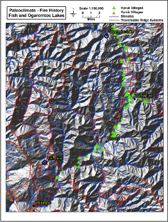
Figure 1. Landscape example of tribal villages, ridge systems, trails, and watersheds featuring two lower elevation lakes. Map produced by J. Werren.
Most fire history studies are segregated into distinct time periods of analysis, which relate back to fire frequency patterns. For example, some are pre- versus post-Euro-American settlement (pre-1850 CE vs. 1850 to the present); some are pre-Euro-American settlement (earlier than 1850); others are postsettlement/pre–fire suppression (1851–1930s or 1940s); and some concern only the post–fire suppression era (after the 1940s). Fry and Stephens state: “It was apparent from the fire record that there were two dramatic changes in the fire pattern. First, fires became less frequent and more widespread in the study area following the substantial Euro-American settlement of the 1850s. Secondly, fires were generally eliminated from the study area after 1924 when fire suppression efforts were becoming more effective in accessible areas.”[21] Many of these studies mention American Indian burning for enhancement of food, materials, basketry, and other resources: “People have affected fire regimes and forests in the study area during different times in known and unknown ways. Before European settlement, native Americans set fires that may have burned through the study area. Local Klamath [mountain] tribes used fire extensively to promote acorns, berry, root and fiber production and to hunt game.”[22] Often, American Indian burning practices are described as augmenting lightning ignitions, because the ignition probability of summer lightning fires is great enough to account for the number of fires observed in the fire scar record for California—no need for additional tribal ignitions. Yet some researchers attest to the significance of tribal burning: “In conjunction with cultural information on settlement . . . it suggests Native American ignitions were likely to have been an important component to the fire regime and vegetation dynamics.”[23] Material cultural reconstructions of California tribal food, material, and related subsistence needs per capita (in villages or tribes) would likely demonstrate that lightning ignitions alone are not adequate to provide the favored site or postfire habitat-specific conditions.[24] Additionally, tribal TEK about fire use and subsistence strategies adapted to fire regimes and landscape conditions can provide other interpretations.
Few studies in California attempt to determine the historical proportions of lightning and American Indian burning.[25] Sampling and analysis methods are rarely able to distinguish between these two types of ignition, other than inferring that the frequency of fire exceeded the lightning ignition potential or finding that fires occurred in seasons other than summer (lightning is more frequent in summer). Evidence that American Indian burning was present is strongest in geographic areas where lightning is rare or limited (coastal areas or lower elevations) and where the seasonality of fire events differs from normal/natural times (determined by scar-ring boundary positions).[26]
Determining the fire source for some seasons can be challenging. For example, the when (season, time of year, or day) and where (geographic locations or vegetation types) for ignitions that are assumed to be natural (i.e., caused by lightning) may coincide with times and areas in which ethnographic documentation indicates that American Indians started fires. Unless multiple lines of evidence support tribal burning rather than lightning for dormant-season fires, there is little ability to distinguish between ignition types. The disciplines note the timing of fires differently: tree rings are interpreted as earlywood, latewood, or dormant season, whereas ethnographic accounts refer to spring, summer, fall, or winter. These seasons are not effectively harmonious with the classification system used by dendroecologists.[27] For example, ethnographic and oral history interviews of tribal elders indicate different seasons for burning grasslands (prairies) and for burning oak savannas with California hazel (Corylus cornuta var. californica) for basketry and for filbert nuts.[28] If these tribal fires, based on fuel load and intensity, burned conifers and thus resulted in fire scars, the tree ring boundary position would indicate that the fires occurred during the dormant season of the tree’s physiological growth stage. This discrepancy between documented ethnographic season of burning and fire scar–tree ring position for time of year does not provide the hard data that would be evidence for finer seasonal characterization of tribal burning practices. Fry and Stephens note that variation in burn season “can be attributed to differences in species composition, local site variables and possibly the timing of Native American ignitions.”[29] Biophysical factors, such as aspect and slope position, that influence the duration of fuel receptivity to ignition may relate to the observed burn season. In other cases, early-season (late spring to early summer, the non–lightning ignition time of year) scar-ring boundary position is considered adequate evidence by some scientists of the contribution of tribal burning, and thus a component of that area’s historical fire regime. Skinner and colleagues report a different season for some fires, based on tree ring position, than lightning ignitions of the summer. This difference in season of burns is a component of the fire regimes. The prehistoric fire regime changed when the Spanish and Americans settled in northern California. Skinner and colleagues state, “We surmise that these changes [in fire regimes] may have been a result of two factors, either individually or in combination: 1) the likely reduction in Native American burning, and 2) reduction in fuel continuity due to [introduced Spanish or American] grazing.”[30]
Recognition of the frequency and seasonality of tribal burning differs among fire history studies. Many fire history studies have been conducted to examine the extent, frequency, and seasonality of fires that characterized “natural” (not cultural) fire regimes.[31] Few studies attempt to characterize the proportion of lightning versus anthropogenic ignitions as a gradient across the landscape. Skinner and colleagues state, “Though native ignitions appear to have been widespread, we do not know the extent of their influence on fire regimes and vegetation at broad scales.”[32] There have been few fire history studies whose research objectives and hypotheses utilized ethnographic–oral history data and archaeological and ecological approaches to examine anthropogenic burning.[33]
There are, however, cases in which paleoclimate or fire history studies have been unknowingly conducted adjacent to archaeological studies or vice versa. The distance between project areas or their actual adjacency should be determined for analysis reflective of the scale of tribal land use (e.g., foraging ranges). In these situations, based on modern GPS location identifiers, individual sediment cores or fire scar samples (i.e., from trees, logs, stumps) can be geospatially located and compared with information from adjacent archaeological sites.[34] Some of the archaeological sites (e.g., camp fire pits, organic residue of bedrock mortars, or macrobotanical remains) can be dated, thus potentially indicating the duration of tribal occupancy, as well as types of cultural activities that were taking place that link to potential tribal fire use practices.[35] Confounding factors with archaeological data are that sites are not always continuously occupied; site use can vary over time because of changes in cultural subsistence strategies and ecological conditions. Alignment of temporal and spatial scales with the resolution (e.g., ± age errors) of the analysis methods presents challenges to identifying association. Paleoclimate sediment cores require fine-scale dissection and extensive dating to increase age precision. Dendrochronological fire histories require careful aging and cross-dating. Analysis of archaeological remains currently is not accurate enough to confidently cross-compare with the former methods. There are cases where paleoclimate or fire history studies do not mention or only have a single sentence about potential or probable tribal fire use, and cases where the archaeological study does not mention or link tribal fire use as a management objective that facilitated the development of the archaeological site. There is a disconnect between the disciplines regarding utilization of the literature and available data and a lack of collaboration among scientists of different disciplines: fire and geography with archaeology and cultural ecology with GIS analysis, laboratory dating techniques, and so on.[36] These multiple lines of evidence are necessary to demonstrate the implications of tribal burning practices over time for specific purposes for particular areas or vegetation community types across the landscape. Thus, this effort forms the foundation by which to examine the importance of fire, resultant pyroecological changes, and significance for tribal economies and landscape biodiversity.
Interdisciplinary studies and data sharing
Modeling from different fields may be applicable or of use to another field.[37] Several examples are provided below. In the case of fire history and archaeological studies, the geospatial data points can be GIS-analyzed using nearest-neighbor or some type of distance association matrix. For example, fire history studies with individual sampling points (live trees, stumps, and logs with datable scars for annual frequency and seasonality) can be used to test those sampling points nearest prehistoric and historic villages or camps or along trails (or more easily traversable ridge systems or riparian zones), the indigenous/tribal travel routes, and ignition/fire use locations. Hypotheses to be tested include whether the sample points nearest the trails or near villages and camps have a higher frequency and proportion of non–lightning season burns. Related to this topic, but scaling up, are related questions: Does the historical extent of areas burned per fire episode correspond with and have any connection to tribal group optimal foraging patterns?[38] Does the historical extent of areas burned and the year and season of burns have a pattern that fits with central-place theory or with optimal foraging theory (OFT)?[39] A variation of this approach was conducted in southern Oregon, in the Umpqua drainage, where historical tribal travel routes were modeled and analyzed using a GIS “least-cost pathway” model in relationship to forest stand age (e.g., Douglas fir regeneration since fire exclusion/suppression) and fire history data.[40] Similarly, Emily Ring conducted a GIS analysis of biophysical landscape properties, fire histories, and tribal travel distances to culturally significant areas of the Karuk along the mid–Klamath River, northern California. To examine the effect of tribal fire use at the landscape scale, modeling and analysis need a control, an area expected to be without tribal influences. Given the extensiveness of trails connecting villages to camps for resource management, these control areas are geographically sparse and would likely occur in more remote locations in the boundary area between tribes or villages.[41] Additionally, the recent history of land use practices (e.g., fire suppression/exclusion, mining, road building, logging) for some sites can degrade or disrupt data collection and prevent accurate interpretations.
The archaeological and cultural ecology disciplines have examined tribal foraging and land use patterns. The energetic budget for groups, families, and individuals is linked to environmental productivity and habitat diversity: where and when desired resources are available.[42] Few cultural ecology–OFT studies have been conducted in the Pacific Northwest and California. None examined environmental productivity as a function of fire-induced habitat diversity.[43] Reconstruction of vegetation composition, structure, and fuel loads for some localities may be possible utilizing archaeological and ethnographic data. Historically documented reasons for where tribal peoples foraged and lived, and why tribes managed resources with fire, coupled with the paleoclimate and fire history studies that characterize (natural vs. cultural) fire regimes, strengthen interpretations of what influenced vegetation conditions for particular areas of the landscape.[44] Archaeological excavations that provide higher-resolution identifications of genera or species, when combined with aging of macrobotanical and faunal remains, can provide details of what botanical and animal resources were valued enough to collect and process.[45] Macrobotanical analysis could identify and quantify the types of plants or parts of plants used. Identified and aged faunal remains could be used to determine the seasonality of occupancy for a site and the types and/or age classes of animals harvested. The identified assemblage of ethnoflora and ethnofaunal remains, when supplemented by ethnographic information, oral histories and tribal TEK, can provide insights to the continuity of tribal subsistence and fire use practices from prehistoric to historic periods. All these data sources can be integrated to build models linking human land use practices to fire events. Potentially, the historical area burned per fire event (extent) can be associated with the foraging area for particular tribal subsistence practices. If tribal groups were burning patches of vegetation for specific resources that would be gathered, then the historical size of burns could be related to the optimal foraging area for valued resources. The area of habitat burned would be comparable to the foraging area of postfire resources to be harvested. To investigate this hypothesis, one would compare the size of resource-gathering or hunting areas with the extent of burning. Some perspectives on tribal seasonal subsistence strategies targeting resources of burned areas have been provided: “It’s a feed plot. Then you got more deer in there than you can think of. Because it is an open food plot. And they will stay there for at least four years before they will move on to another burn. By that time another burn will kick in and the feed will be better there . . . because all animals move in there, once deer move in there then every other animal moves in there. Every animal moves in there. It becomes a big food plot.”[46] Different data sets derived from several methods of investigation can support or refute the predictions of GIS-based paleoclimate, fire, or optimal foraging models better than the mere presence or absence of archaeological evidence for tribal use of an area or site. The limitations of each method should also be recognized. For example, a model may predict that tribes were burning a specific area for a particular resource. But if evidence that people used the resource is not found at the archaeological sites, then the model’s predictions could be questioned.[47]
Archaeological studies of tribal foraging often look at linear distances from village to resource collection areas or sites but not necessarily at the (post-fire-induced, vegetation seral stage) temporal productivity of the site to which people traveled to hunt and gather. Skinner and colleagues found that topography, aspect, slope position, and substrate/soil affect the size of burn areas.[48] Additionally, the distance from the coast (west-moist to east-dry), site productivity (i.e., fuel recruitment), vegetation composition, structure, and fuel load continuity influence fire behavior and areas burned. Little is known about how landscape fire patterns, by vegetation community and seral stage, influenced tribal foraging and related subsistence strategies.[49] If the severity of each fire event was equated to biomass estimates of valued resources by type (foods, medicines, and materials), then there could be an opportunity for extrapolating the linkages of fire regime landscape patterns to tribal subsistence activities for specific vegetation (forest community) types. A scaled landscape assessment may be possible for different burn areas and foraging patch size, reflective of the tribal cultural adaptations to various climate-induced fire effects. For example, drier years have potentially greater fire spread and less resource productivity and required tribal groups to modify fire use and adapt foraging strategies.[50] Tribal seasonal travel and resource strategies were likely linked to differing fire patterns across a range of similar vegetation types, but with each type having been burned at different frequencies.[51] Thus developed a staggering of seral stages of similar vegetation communities across the landscape, differing by time since burn and by severity of burn.[52] A landscape with burns in different years with mixed severities provided greater diversity of seral stages among vegetation types that facilitated tribal acquisition of valued resources.
If fire history and severity studies demonstrate a patterning of fire boundaries based on biophysical factors, then how much of these former patterns are, in part, the results of former tribal burning practices as well? And if this issue is not addressed or considered by researchers, or only briefly mentioned as not examined or beyond the scope of their research, then these studies can potentially marginalize and exclude the importance of tribal adaptive practices and management systems. The implications of this could lead managers to question why tribal people should be consulted and tribal knowledge should be incorporated into contemporary fire and fuels management, or why cultural burning should be a component of modern fire management. For example, Halofsky and colleagues concluded: “Uncertainties also exist regarding the influence of anthropogenic factors on M-S [mixed-severity] regimes.”[53] Conclusions will likely continue to be uncertain if researchers do not attempt to examine the effects of tribal burning practices using multiple lines of evidence.
Early historic landscape photographs, vegetation surveys,[54] and related survey records provide a basis for vegetation reconstruction for an era when fire regimes were transitioning from tribal to Euro-American management.[55] One integrated methodological approach would be to take these vegetation base layers, incorporate archeological data on prehistoric villages and camps and historical data on trails[56] (which connect villages and camps to resource collection areas), cross-referenced with fire history data (regarding the frequency, season, and extent of fire events), and then apply optimal or central-place foraging models. Utilizing traditional ecological knowledge and ethnographic information, the investigator could then reconstruct which fire-modified vegetation types at a given scale were potentially being used by season. Then the extent of fire by vegetation type across the landscape could be used to develop models for group size (family or village) based on the energetic resources, such as the amount and nutritional value of foods, that were collected in the burn areas over time. Seral stage development as a factor of fuel load, stand structure, and composition reflects time since fire by severity. Foraging patch size for culturally significant use areas associated with seral stage could be inferred from local fire histories and fire effects studies examining vegetation, biodiversity, wildlife, and fuel properties. Some areas of the landscape were more highly sought after and favored than others for tribal foraging. In the western Klamath Mountains, Emily Ring found that these culturally significant areas had the most diverse biophysical settings and fire histories important for supporting tribal economies.[57]
A scaled-up approach would be to describe a geographic landscape area of interest, suitable to support a village (one hundred to three hundred people), overlay the above interdisciplinary data, and then incorporate federal agency fire atlas records of historic lightning ignitions and anthropogenic fires.[58] The investigator could then incorporate fire ignition and spread modeling, such as FARSITE, to emulate tribal burning practices at geographically discrete locations (e.g., trails, camps, or villages). The probability of spread from these modeled anthropogenic ignition points could then be compared with the historical extent of fires.[59]
Scaled Approaches to Integrating and Incorporating Tribal TEK and Fire–land Use Practices
An approach to consider for testing the extent and influence of anthropogenic tribal fire use practices on landscape-level vegetation diversity is to conduct plot- to stand-scale studies to replicate or simulate tribal fire and land use practices.[60] Community-based research using a scaled approach regarding the things of interest (e.g., animal, plant, fungi, from quadrat [one square meter] to plot [one square hectare] to stand [one square kilometer] to landscape [>ten square kilometers] scale) may offer more utility in demonstrating how indigenous burning and land use practices link into ecological scales of interest for researchers and managers. Some difficulty has been encountered when trying to utilize ecological studies of fire effects conducted at various scales to interpret how cultural use quality is affected or changed. The extent of area, “patch,” from which resources are harvested varies in response to the density, quantity, and quality of tribal valued resource sought. Concerns related to this sampling design include how to address local tribal community fire and fuels management priorities as a scaled approach ranging from the site or “patch” to landscape. Selecting the appropriate scale in the context of national policies and programs directed at hazardous fuels reduction, wildland fire management, climate change and adaptation, and federal trust or fiduciary responsibilities to indigenous/tribal peoples is important. Academic and agency researchers and land managers often do not know or have not been adequately trained in how to approach, coordinate with, or consult tribal/indigenous communities, organizations, or governments. Regarding tribal TEK and fire, Mason and colleagues related that this cross-cultural barrier can inhibit understanding of indigenous community values and priorities for research and management.[61] A goal would be to develop the best available science, based on a sampling methodology and hypothesis, in collaboration with indigenous peoples. Respectful conduct and acknowledgment of differences in research approaches, beliefs, and values should be observed.[62] Other challenges that can arise when working with tribal governments and practitioners concern scheduling, reviews, approvals, and active participation. These sociocultural barriers lessen with more personable interactions and face-to-face meetings that result in building trust.
Landscape-level fire studies incorporating new and established technology can have great utility, but they may not be completely understood by tribal research partners. Landsat, LIDAR, and GIS applications are a few that offer detailed data on landscape condition.[63] In statistically sound research sampling designs, the sample necessary for statistically valid and rigorous inference may encompass several tribal groups’ ancestral territories. When considering the influence of climate or local site conditions, the TEK of indigenous groups can be informative about vegetative and pyro-diversity locally, when scaled up with known climate and biophysical controlling factors.[64]
Wildland fires (defined as wildfires or prescribed burning by the National Wildfire Coordinating Group) that support multiple resource benefits can be used as surrogates for tribal fire treatments to examine pre- and postfire effects by fire behavior, intensity, and resultant severity, although not all wildfires or prescribed burns emulate tribal ignition patterns, burn at tribal preferred locations or resources, or produce desired fire effects. When working on the Orleans Complex–Somes fire in 2006 (a wildfire in northwestern California), a US Forest Service Fire Behavior Assessment Team (with Jo Ann Fites as team leader) collaborated with the Karuk Tribe, Incident Command Team, and me in my capacity as resources adviser to select areas where the wildfire and burnout/back-burning operations were expected to spread (fig. 2). Culturally significant areas with a variety of vegetation types were instrumented and monitored for prefire, immediately postfire, and one-year postfire effects on these tribally valued habitats. The data (flame height, rate of spread, fuel consumed, duration and temperature of heat, vegetation cover and density) provided valuable insights as to how the reintroduction of fire, after being absent for many years (decades), affected fuel and vegetation properties, all associated with resultant cultural use quality. These data also provided valuable fire effects information that can be used to interpret the postfire cultural use quality of the sites.[65]
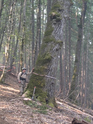
Figure 2. Example of living cultural resource potentially impacted by fire management: tanoak acorn tree and archaeological (acorn food processing) site. Some archaeological sites, such as this location, had specific mitigation measures implemented to protect their heritage (artifacts) and ecological (old-growth trees) features.
Prescribed burns being conducted by agencies, tribes, community organizations (e.g., Fire Safe Councils), or private landowners provide opportunities to study how the tribal cultural use quality of a vegetation community or patch is modified with preburn treatments, such as hazardous-fuels reduction (e.g., chainsaw thinning and pile burning). There is a need for experiments on culturally significant use species.[66] Studies conducted where sampling methods were developed with tribal basket weavers and practitioners indicate that ecological and fuel monitoring (e.g., fire effects) matrices need to be cross-walked—that is, integrated with tribal practitioner criteria and assessment variables.[67] The integration and interface of similar yet different variables of interest can pose some sampling design and statistical analysis challenges. Yet this approach is more likely to be of value and utility to local tribal communities, and it would assist scientists and managers with developing more responsive and applicable fire and fuel management prescriptions. Specific to fuel reduction and fire management for basketry plants, stem morphology—diameter-to-length ratios of “good shoots”—per individual shrub clump or per unit area and canopy cover or closure are of greatest interest and have been measured at the quadrat scale.[68] With food plants, the sample unit and variables of interest are density of nut, seed, bulb, or root per unit area, linked in scale to individual (plant, shrub, or tree) mortality, basal area, or density of stems, which may be more appropriately measured at the plot to stand scale. These prescribed burns enhance the quantity and quality of traditional basketry materials and foods important to contemporary tribal economies and the maintenance of cultural practices. In such research the experimental data of interest are the highly valued basket material—shrub shoots. “All the weavers harvested quality hazel. . . . This is the first hazel burn in many years and it certainly put a big smile on the faces of the weavers.”[69] I counted and measured the hazel shoots that basket weavers gathered to assess season of burn and cultural use quality of the burn site.
A greater effort for the inclusion of tribal/indigenous values, perspectives, and knowledge into research and management can be facilitated with symposia, conferences, or workshops. Time availability, conflict with day-to-day priorities, and funding for tribal/indigenous involvement are often limiting factors to tribal participation, however. Events co-hosted by or organized with tribal governments or departments and programs and indigenous organizations (e.g., basket weavers) have been found to be more successful.
Researchers and managers can be exposed to and learn of indigenous fire and fuel management priorities and values via regional and national training, educational institutions, or symposia. For example, the Rx-510 Advanced Fire Effects course at the National Advanced Fire and Resource Institute’s interagency training center (Tucson, Arizona) offers a lecture on tribal burning practices and working with tribes. Other related approaches include agency or academic training courses, guest lectures, and curriculum development.[70] Such cross-cultural education efforts can facilitate improved working relationships among tribal communities, organizations, governments, and fire researchers and managers. Additionally, these efforts, as successful examples, can facilitate improved working relationships during larger wildfire incidents or fire and forest management in regard to how best to develop and establish formal agreements between tribes and agencies.
Agency-tribal agreements formalize a government-to-government relationship between agencies and tribes/indigenous peoples. For example, the US Forest Service has memoranda of understanding with the Bureau of Indian Affairs and tribes for cost and resource sharing. These agreements serve as types of contracts for services and collaborations between the signatory parties. Specific to fire and fuel management programs and projects are fire management agreements. These agreements strengthen the government-to-government consultation and coordination efforts by extending fire and fuel-related cooperation. For wildland fires occurring within an indigenous/tribal ancestral territory, there is a designated tribal government representative whom agencies contact when incidents occur. Related to, and associated with, resource advising duties are heritage resource consultants. These tribal fire-line-qualified or experienced individuals work with local agency and incident management teams to protect and mitigate the effects of fire and suppression activities on archaeological, heritage, cultural, and (culturally significant) natural resources (see fig. 2).[71] Additionally, if the tribe has individuals with certifications and valid fire-line qualifications, then these tribal crews can be used for suppression, containment, resource advising, and Burn Area Emergency Response efforts. Any other related fire management incident position (e.g., certified tree fellers, water tenders, brush/limb chippers, burn bosses) should also be able to be incorporated in the agreement providing for tribal preference as sole source or direct hire contracting in capacities scaled to meet the suppression resource needs of the fire.
Individuals in the designated tribal representative and heritage resource consultant positions can serve as pre–fire season interdisciplinary team members to identify values at risk for Wildland Fire Decision Support System (e.g., WFDSS-RAVAR) planning efforts.[72] Interagency agreements for transfer of funding to support tribal participation may be needed. Preseason wildfire risks assessment of which locations are expected to burn can identify areas of mutual interest, values to be protected, and available suppression resources. Tribes are sometimes limited by who has fire-line or related qualifications and certificates. These challenges can be overcome by interagency and tribal training and collaborative fire and fuel management programs.[73] Historically, many Native American tribes who formerly were dependent on fire-induced environmental change are now part of the fire suppression and management interagency workforce.[74] Innovative fire management training could reunite indigenous people as contemporary fire managers with their ancestral fire-adapted environments.[75] In California, tribal practitioners dependent on having prescribed burns to foster basketry, food, and other fire-enhanced resources have to work with governmental agencies and nongovernmental organizations (e.g., the Nature Conservancy or local Fire Safe Councils). Some tribes have fire crews that work on wildland fires; these positions can be a bridge between tribal traditional and contemporary fire management practices and related knowledge.
There is a need for more volunteer and internship opportunities for tribal/indigenous student youth and adults with natural resources fire and fuel programs and projects. Agency and academic researchers (scientists and graduate students) could seek funding for the field training of tribal youth and adults in research and monitoring efforts. This could serve the need for recruitment and potential future retention of tribal people in the fields of natural resources, forestry, and fire and fuel management. It would also expose students or volunteers to these academic and management fields, as well as encourage them to share their TEK with these projects. This kind of community-based plan would seek out and select interested tribal youth; over many years, tribal youth would be mentored in preparation for their seeking academic or professional degrees or certificates when adults. Community-based planning could foster placing indigenous people in professional agency or tribal government departmental positions. Such educational and career opportunities would also nurture connections to traditional homelands, family, community, and economic self-sufficiency.
Closing Thoughts on Trails: Walking a Path Hand and Hand to Take Us Where We Need to Go
Fire use among Australian Aboriginal and California tribal groups has changed significantly in the last two hundred years as the result of colonization and fire suppression by nonindigenous peoples. Along with the sociocultural demographic changes, changes in the fire regimes and climate have taken place. The debate as to the extent or impact of tribal burning practices at the landscape scale remains an academic focus.[76] To describe historical, precolonization fire regimes as natural marginalizes the importance of anthropogenic fire management on biodiversity, biocultural legacies of vegetation and wildlife diversity and populations, and the complexity of tribal TEK regarding the interconnectedness of ecological processes and human adaptive practices. Many scientific disciplines, in their approaches and methodologies, are limited in their ability to distinguish between anthropogenic and natural (i.e., lightning) landscape fire effects. Yet when a multidisciplinary cross-scale approach is taken, these issues can be examined from different perspectives, with the strengths of each of these disciplines combined to reduce the limitations (or weaknesses) inherent in them individually.
Scientists and managers need to be more familiar with historical tribal fire use and land management practices, because these link to contemporary Aboriginal and tribal community fire and fuel management issues. Prevalent among some Western scientists and managers is the view expressed by Burcham, then California State forester, in 1959: “If we find controlled burning valuable we are not required to look to the Indians for precedent to justify its use—it will stand or fall on its own merits. It must be applied by us in the light of modern research, and through understanding of ecological processes, not on the basis of traditions that stand in the dim past.”[77] Scientists and managers could be more inclusive of indigenous people in fire and fuels research and monitoring of fire effects. Critical to this are understanding and respecting indigenous values and TEK pertaining to natural resources, fire, and fuel management.[78] Regional and national policies that direct fire and fuel management priorities are increasingly being more inclusive of indigenous rights.[79] Consultation and coordination between federal agencies and tribes are beginning to facilitate more tribal participation in agency management.[80] The incorporation of tribal TEK and participation of tribal practitioners in research will affect how science is conducted and the applicability of the “best available science” that guides management.
Trails linked people to places. The trail systems established by California tribal groups networked individuals and families with desired resources, from coastal to alpine environments across a variety of habitats with differing fire regimes and plant communities. Most trails followed the edge of water courses and ridges, with some minor deviations connecting resource use areas of various habitats. Some of these trail systems have been in use for millennia. In northern California, and likely elsewhere in the western United States, these trail systems bisected fire-modified vegetation communities, as well as watersheds or various subdrainages. Over many years, tribal people learned from natural lightning ignitions how to gauge the probability of ignition based on fuel receptivity to burning and at some point began to manipulate habitats with the use of fire. In the rugged, mountainous terrain of northern California, areas adjacent to trails were likely the first locations other than the villages to be deliberately burned by Native Americans. Over time, and in addition to the modifications produced by climate changes, the application of tribal TEK and diversified fire use began to modify natural fire patterns to more anthropogenic desired patterns (time-since-burn productivity providing culturally significant ecological goods and services). Results of colonization—contact with foreign diseases and then explorers and settlers—depopulated tribal groups from many areas of northern California. Reduced tribal populations resulted in fewer tribal ignitions and likely brought about a change in fire regimes and vegetation communities.[81]
Using trails was the most efficient way to traverse the landscape, and during Euro-American exploration and colonization, these trails were used by nontribal people—first trappers and explorers, then in significant numbers gold miners and settlers—to explore, exploit, and settle tribal territories. Historical accounts relate how early settlers, mainly cattlemen and sheepherders, used these trails and fire to promote forage and more open habitat. A Karuk man describes early trail use: “This trail was used to get there, and it was also used to drive stock [cattle] along to the pastures on the south side of Chimmikanee Ridge. This originally was open grassland, which was maintained by Indian burning. Over hundreds and thousands of years the burning had created open grasslands for deer and elk forage. When the whites came it was used as pasturage at certain times of the year. Now it has grown over with oaks, madrone, and conifers.”[82]
The prehistoric tribal trails, next used by Gold Rush miners and as American settler pack-mule trails, then as roads, were often the first areas of the landscape, besides former villages (now American towns or residences), to be used for US governmental fire suppression policies and management actions. The areas of the landscape most frequently burned by tribal people and then early American and Indian cattlemen became the most easily accessed, and as such they were areas where fires could be readily suppressed. “The cattlemen used to drive cattle up there [higher elevation mountains] to graze. There was plenty of room because they used to keep the forest floor burnt to keep the brush down just like the Indians used to do. A fella would see a patch of brush and just toss a match into it. Since the Forest Service took over, though, every thing’s grown back and you can’t hardly get around anymore.”[83] These areas began to convert, changing vegetation community composition and structure and with increased fuel loads as the result of the cessation of tribal burning.[84] These changes in vegetation and fire are evident in paleoclimate and fire history studies. Community-based ignitions, by Indians and American settlers, were eventually outlawed and considered arson by federal and state agencies starting in 1910 and were replaced with more effective agency-directed fire suppression and exclusion practices. Now, these same trail systems, with their archaeological and heritage resources, are also some of the most desired areas for suppressing and containing wildfires. This creates conflict over the protection of heritage and archaeological sites versus construction of fire contingency lines.[85] Additionally, these trail segments can pose some resource management conflicts and may require mitigation of contemporary forest and fuel management practices, such as timber harvesting to reduce hazardous fuels.[86]
The former resource areas along and adjacent to trails are contemporary culturally desired management areas, because many tribal groups have family histories and knowledge of the uses of these places. These culturally significant areas were often the most biophysically diverse and productive areas of the landscape. When considered in the context of landscape-level conservation of biodiversity and reintroduction of fire as an ecological process, these tribally significant areas also have contemporary sociocultural and economic value. Many of the various studies and methodologies described above are related to and are applicable to these landscape-scale trail systems. These interrelated issues are not well understood or incorporated into contemporary agency management approaches and associated resource plans.[87]
Lastly, Aboriginal and tribal peoples have a different and unique relationship with fire-prone, fire-adapted environments than Western society does. Some tribes and members of the public feel that indigenous groups should be involved at all levels with fire and fuel research and management. Many indigenous people consider fire to be not only a sacred gift and tool but also a valuable mechanism of environmental change and renewal. Utilizing former trail systems, many now converted to roads, can foster a reconnection to place for tribal communities, support contemporary livelihoods, and allow the incorporation of TEK into fire and fuel research and management to protect or restore valued resources.

Frank Kanawha Lake is of Karuk, Seneca, Cherokee, and Mexican ancestry and was raised in northern California. He participates in tribal subsistence and ceremonial activities and associated traditional practices and arts. Frank holds a bachelor of science degree in “integrated ecology and culture,” with a Native American studies minor, from the University of California, Davis (1995), and received his PhD in environmental sciences, with an ecology emphasis, from Oregon State University (2007). Currently, he is a research ecologist with the US Forest Service Pacific Southwest Research Station’s Fire and Fuels Program.
Acknowledgments: Components of my research related to paleoclimate, fire history, and tribal ethnographic archival research were supported by a National Science Foundation Geography and Spatial Sciences Grant (GSS-0964261), “Did Native Americans Significantly Alter Forest Structure in California? A Paleoecologic Reconstruction of Vegetation and Fire History from Two Different Ecosystems,” awarded to Dr. Scott Mensing and Jeff Crawford, University of Nevada–Reno, with a sub-award to the US Forest Service Pacific Southwest Research Station. The most recent results of that work are this essay and Crawford’s dissertation (2012). Thanks are due to Debra Bruce for her editorial assistance and to an anonymous reviewer of earlier drafts of this manuscript.
[1] See Henry T. Lewis, “Patterns of Indian Burning in California: Ecology and Ethnohistory,” in Before the Wilderness—Environmental Management by Native Californians, ed. Thomas C. Blackburn and Kat Anderson (Menlo Park, CA: Ballena Press, 1993), 55–116; M. Kat Anderson, Tending the Wild: Native American Knowledge and the Management of California’s Natural Resources (Berkeley and Los Angeles: University of California Press, 2005); Frank K. Lake, “Traditional Ecological Knowledge to Develop and Maintain Fire Regimes in Northwestern California, Klamath-Siskiyou Bioregion: Management and Restoration of Culturally Significant Habitats” (PhD diss., Oregon State University, 2007), available online at http://ir.library.oregonstate.edu/dspace/handle/1957/6222.
[2] These remarks are by C. Raymond Clar, who was chief deputy state forester from 1941 to 1953; he is quoted in Lewis, “Patterns of Indian Burning,” 55.
[3] Cathy Whitlock et al., “Paleoecological Perspectives of Fire Ecology: Revisiting the Fire-Regime Concept,” Open Ecology Journal 3 (2010): 6–23; Donald A. Falk et al., “Multi-scale Controls of Historical Forest-Fire Regimes: New Insights from Fire Scar Networks,” Frontiers in Ecology and Environment 9, no. 8 (2011): 446–54; Jennifer R. Marlon et al., “Long-Term Perspective on Wildfires in the Western USA,” Proceedings of the National Academy of Science–Early Edition 109, no. 9 (2012): E535–43, available online at www.pnas.org/cgi/doi/10.1073/pnas.1112839109 (last accessed on December 12, 2012).
[4] Cathy Whitlock et al., “Comparison of Charcoal and Tree-Ring Records of Recent Fires in the Eastern Klamath Mountains, California, USA,” Canadian Journal of Forest Research 34 (2004): 2110–21; Christy E. Briles et al., “Regional and Local Controls on Postglacial Vegetation and Fire in the Siskiyou Mountains, Northern California, USA,” Palaeogeography, Palaeoclimatology, Palaeoecology 265 (2008): 159–69. The paleoclimate study sites from Whitlock et al. and Briles et al., and their reported changes in fire frequency associated with these sites, have not been adequately compared to the adjacent regional archaeological synthesis of human migration, settlement, and transitions in cultural phases reported by Thomas J. Connolly, “A Culture-Historical Model for the Klamath Mountain Region of Southwest Oregon and Northern California,” Journal of California and Great Basin Anthropology 10, no. 2 (1988): 246–60. Tribal people have occupied the region for over nine thousand years, enduring long-term climate shifts and vegetation changes, as recorded by Briles et al., “Regional and Local Controls on Postglacial Vegetation and Fire,” and by other paleoclimate studies noted above. Both lakes studied by Briles et al. are located on historic trails and along prehistoric and historic indigenous trade routes. Regional archaeological data suggest human use and occupation of sites at similar elevations and with similar vegetation as those studied by Briles and colleagues. See Connolly, “Culture-Historical Model for the Klamath Mountain Region.”
[5] Alan H. Taylor and Carl N. Skinner, “Fire History and Landscape Dynamics in a Late-Successional Reserve, Klamath Mountains, California, USA,” Forest Ecology and Management 111 (1998): 285–301; Alan H. Taylor and Carl N. Skinner, “Spatial Patterns and Controls on Historical Fire Regimes and Forest Structure in the Klamath Mountains,” Ecological Applications 13 (2003): 704–19; Whitlock et al., “Comparison of Charcoal and Tree-Ring Records”; Briles et al., “Regional and Local Controls on Postglacial Vegetation and Fire”; Jeff N. Crawford, “Evidence for Native American Land-Use Impacts on Forest Structure and Fire Regimes in the Lower Klamath River Region of California” (PhD diss., University of Nevada–Reno, 2012); Marlon et al., “Long-Term Perspective on Wildfires.”
[6] Crawford, “Evidence for Native American Land-Use Impacts”; Marlon et al., “Long-Term Perspective on Wildfires.”
[7] Briles et al., “Regional and Local Controls on Postglacial Vegetation and Fire.” Crawford’s aging of macrofossils was assisted by Susan Zimmerman, Center for Accelerator Mass Spectrometry, Livermore, CA, who analyzed and provided many accelerator mass spectrometry radiocarbon dates on macrofossils per core, more than previous researchers.
[8] Carl N. Skinner, Alan H. Taylor, and James K. Agee, “Klamath Mountains Bioregion,” in Fire in California’s Ecosystems, ed. N. G. Sugihara et al. (Berkeley and Los Angeles: University of California Press, 2006), 170–94.
[9] Bolan Lake is one of Briles et al.’s study sites. They conclude: “The Bolan Lake record suggests that climate changes occurring on long time scales across the region are just as important in shaping present-day forest patterns and composition as natural and human disturbances evident on shorter and more local scales. Therefore, the record highlights yet another factor, long-term climate change, which must be considered when explaining the diversity of the Siskiyou Mountains” (“Regional and Local Controls on Postglacial Vegetation and Fire,” 55).
[10] Crawford selected project sites after consulting the Karuk and Yurok Tribes. See Marlon et al., “Long-Term Perspective on Wildfires,” for use of models.
[11] Regarding ethnographic methods, see M. Kat Anderson, “The Contribution of Ethnobiology to the Reconstruction and Restoration of Historic Ecosystems,” in The Historical Ecology Handbook: A Restorationist’s Guide to Reference Ecosystems, ed. Dave Egan and Evelyn A. Howell (Covelo, CA: Island Press, 2001), 55–72; and M. Kat Anderson, “The Use of Fire by Native Americans in California,” in Sugihara et al., Fire in California’s Ecosystems, 417–30. Many historical accounts about the Klamath-Siskiyou region are compiled in Reg Pullen, “Overview of the Environment of Native Inhabitants of Southwestern Oregon, Late Prehistoric Era,” report, US Department of Agriculture, Forest Service, and Department of the Interior, Bureau of Land Management, Medford District (Bandon, OR: Pullen Consulting, 1996), IV-2. The southwest Oregon tribal people shared the Bolan Lake and Page Mountain area with the Karok. In describing intermarriage and travel of tribes, Pullen notes: “Their route took them up Indian Creek from Happy Camp and along a ridge to Bolan Lake. After a short rest the group made its way through the Illinois Valley to O’Brien” (61). The lake area was important enough to warrant mention by several tribal informants. This trail along Thompson ridge to Bolan Lake bisects the fire history study site of Taylor and Skinner (“Fire History and Landscape Dynamics”).
[12] John P. Harrington, Tobacco among the Karuk Indians of California, Bureau of American Ethnology Bulletins, 94 (Washington, DC: Smithsonian Institution, 1932), 1–284. See also Lewis, “Patterns of Indian Burning”; Karuk Tribe and Cultural Solutions, “Karuk Forest Management Perspectives: Interviews with Tribal Members,” vol. 1, “Report and Interview Transcripts,” and vol. 2, “Appendices” (USDA Forest Service, Klamath National Forest, Yreka, CA, 1999).
[13] Marco Conedera et al., “Reconstructing Past Fire Regimes: Methods, Applications, and Relevance to Fire Management and Conservation,” Quaternary Science Reviews 28 (2009): 555–76; Whitlock et al., “Paleoecological Perspectives of Fire Ecology”; Falk et al., “Multi-scale Controls of Historical Forest-Fire Regimes”; Crawford, “Evidence for Native American Land-Use Impacts”; Marlon et al., “Long-Term Perspective on Wildfires.”
[14] See Megan K. Walsh, Cathy Whitlock, and Patrick J. Bartlein, “1200 Years of Fire and Vegetation History in the Willamette Valley, Oregon and Washington: Reconstruction Using High-Resolution Macroscopic Charcoal and Pollen Analysis,” Palaeogeography, Palaeoclimatology, Palaeoecology 297 (2010): 273–89.
[15] Marlon et al., “Long-Term Perspective on Wildfires”; Crawford, “Evidence for Native American Land-Use Impacts.”
[16] Walsh et al. found different charcoal abundance records representative of fire frequency between the lakes studied in the Willamette Valley where climatically the fire frequency should have been similar. Crawford’s charcoal-fire frequency record similarly differed between his two lake research sites, suggesting a combination of anthropogenic and climate influences on the fire regime as well. See Walsh, Whitlock, and Bartlein, “1200 Years of Fire and Vegetation History”; Crawford, “Evidence for Native American Land-Use Impacts.”
[17] For an overview of studies using such techniques, see David A. Fredrickson, “The North Coastal Region,” in California Archaeology, ed. Michael J. Moratto (reprint, Salinas, CA: Coyote Press, 2004), 471–527; Kathryn R. Winthrop and Robert H. Winthrop, “Konomihu Studies: Ethnology and Archaeological Data Recovery, CA-SIS-1457” (report prepared for the US Forest Service, Klamath National Forest, Contract 53-91W8-8-8103, 1991). See Paterson’s contribution to the present volume for a similar Australian critique.
[18] These methods, preferably using conifers, are applicable in temperate regions where tree interannual growth rings form.
[19] The trees analyzed are pines (Pinus sp.), cedars (Calocedrus decurrens, Chamaecyparis sp.), and Douglas firs (Pseudotsuga menziesii).
[20] The following studies utilized pines, cedars, and Douglas firs, among other conifers: Taylor and Skinner, “Fire History and Landscape Dynamics”; and Taylor and Skinner, “Spatial Patterns and Controls on Historical Fire Regimes”; Danny L. Fry and Scott L. Stephens, “Influence of Humans and Climate on Fire History of a Ponderosa Pine–Mixed Conifer Forest in the Southeastern Klamath Mountains, California,” Forest Ecology and Management 223 (2003): 428–38. Steven Norman, of the US Forest Service, aged coastal redwoods. His data, along with other coastal redwood fire history studies, are included in Craig G. Lorimer et al., “Presettlement and Modern Disturbance Regimes in Coast Redwood Forests: Implications for the Conservation of Old-Growth Stands,” Forest Ecology and Management 258 (2009): 1038–54.
[21] Fry and Stephens, “Influence of Humans and Climate,” 431. They continue: “To describe these differences, FRI’s [fire return intervals] and season were divided into three periods: presettlement (1750–1849), settlement (1850–1924), and suppression (1925–2002).”
[22] Taylor and Skinner, “Fire History and Landscape Dynamics,” 288.
[23] Fry and Stephens, “Influence of Humans and Climate,” 434.
[24] For examples of ethnographic work and for tribal material cultural reconstruction of natural resources, see Anderson, “Contribution of Ethnobiology”; Anderson, Tending the Wild; M. Kat Anderson, “The Fire, Pruning, and Coppice Management of Temperate Ecosystems for Basketry Materials by Californian Indian Tribes,” Human Ecology 27, no. 1 (1999): 79–113. Material cultural reconstruction links a tribal manufactured object (such as a basket) with an ecological process (such as fire). For example, per year, a village of 200 people with 20 families, with 2 basket weavers per family, needs 10 new baskets per family per year. Different types of baskets require between 500 and 1,500 new shoots for construction. To make a basket that requires 1,000 hazel shoots of similar size (stem diameter and length), shoots are collected from 50 different hazel shrubs, from 2 different geographically dispersed locations, or “patches,” burned during a similar season. Two properly burned sites per basket multiplied by 10 baskets multiplied by 40 weavers per village annually would require approximately 800 different patches from the California black oak, hazel, Pacific maple forest habitat type. Lightning fires do not provide that site specificity or the predictability of burning enough hazel shrubs that are readily accessible by trail near villages or camps.
[25] Scott L. Stephens, Robert E. Martin, and Nicholas E. Clinton, “Prehistoric Fire Area and Emissions from California’s Forests, Woodlands, Shrublands, and Grasslands,” Forest Ecology and Management 251 (2007): 205–16; Jan W. van Wagtendonk and Daniel R. Cayan, “Temporal and Spatial Distribution of Lightning Strikes in California in Relation to Large-Scale Weather Patterns,” Fire Ecology 4, no. 1 (2008): 34–56.
[26] For examples in the northern California Coast Range, see Carl N. Skinner et al., “Human and Climate Influences on Fire Occurrence in California’s North Coast Range, USA,” Fire Ecology 5, no. 3 (2009): 76–99; or Jon E. Keeley, “Native American Impacts on Fire Regimes of the California Coastal Ranges,” Journal of Biogeography 29 (2002): 303–20. For the southeast Klamath Mountains, see Fry and Stephens, “Influence of Humans and Climate.”
[27] No researcher has systematically compared tribal seasons of burning for different resource objectives with geographically applicable fire histories.
[28] See Lewis, “Patterns of Indian Burning”; Omar C. Stewart, Forgotten Fires: Native Americans and the Transient Wilderness, ed. and with introductions by Henry T. Lewis and M. Kat Anderson (Norman: University of Oklahoma Press, 2002); Lake, “Traditional Ecological Knowledge to Develop and Maintain Fire Regimes.”
[29] Fry and Stephens, “Influence of Humans and Climate,” 434.
[30] Skinner et al., “Human and Climate Influences,” 89. Seasonal grazing of sheep and cattle was an important economic enterprise for early historic northwestern California Indians. Indian families utilized the same trail networks as their ancestors, from low elevations near villages or homesteads to the high country; see figure 1 for traversable ridges. The introduction of horses facilitated travel and packing. Landscape burning to improve forage was an important practice that accompanied cattle- and sheepherding efforts. Hunting and gathering of favored mountain resources (e.g., medicinal and basketry plants, berries, and other food or materials) were dependent on burning particular vegetation communities in different areas each year.
[31] For discussion of natural versus indigenous cultural fire regimes, see Thomas M. Bonnicksen et al., “Native American Influences on the Development of Forested Ecosystems,” in Ecological Stewardship: A Common Reference for Ecosystem Management, vol. 2, ed. W. Sexton et al. (Netherlands: Elsevier Science Press, 1999), 439–69. For coastal redwood forests, see Lorimer et al., “Presettlement and Modern Disturbance Regimes.”
[32] Skinner, Taylor, and Agee, “Klamath Mountains Bioregion,” 176.
[33] For the northern California Klamath Mountains, see Crawford, “Evidence for Native American Land-Use Impacts.” For California’s central coast, see Rob Cuthrell, Chuck Striplen, and Ken Lightfoot, “Exploring Indigenous Landscape Management at Quiroste Valley: The Archaeological Approach,” News from Native California 22, no. 3 (2009): 26–29.
[34] See Steven Norman’s fire history studies in Lorimer et al., “Presettlement and Modern Disturbance Regimes,” compared with ethnographic and archaeological data from Shannon Tushingham, “The Development of Intensive Foraging Systems in Northwestern California” (PhD diss., University of California–Davis, 2009).
[35] For example, acorn protein found on stone mortars has been carbon-dated, and tribal fire use for oak acorn resource enhancement to reduce nut insect pests or to clear understory vegetation and surface fuel is documented.
[36] A greater effort is being made among researchers of different disciplines to collaborate, coordinate, and align methodologies. See the National Science Foundation’s Dynamic Coupled Human and Natural System section and research conducted by the Laboratory of Tree Ring Research, University of Arizona.
[37] This may stem from academic degree programs and lack of interdisciplinary exposure.
[38] I do not know of any research conducted comparing how the extent of tribal foraging of burn patches for valued resources is related to the extent of prehistorical fires (area burned) derived from applicable fire history studies. For example, for the Klamath mountains, compare the findings of Taylor and Skinner, “Fire History and Landscape Dynamics,” for median burn area as 350 (±217) ha (range 28–1,340 ha), and in Taylor and Skinner, “Spatial Patterns and Controls on Historical Fire Regimes,” for the pre-Euro-American period as 106 ha (range 25–1,541 ha) to anthropological data for hunter-gather foraging distance and amount of area needed to access and acquire sufficient resources. Compare vegetation seral stage and diversity to resource abundance and productivity to fire extent (i.e., patch size).
[39] I do not know if such research is being conducted in the Pacific West. For Australian Aboriginal examples, see Douglas W. Bird, Rebecca Bliege Bird, and Christopher H. Parker, “Aboriginal Burning Regimes and Hunting Strategies in Australia’s Western Desert,” Human Ecology 33, no. 4 (2005): 443–64.
[40] See Kenneth R. Carloni, “The Ecological Legacy of Indian Burning Practices in Southwestern Oregon” (PhD diss., Oregon State University, 2005), available online at http://ir.library.oregonstate.edu/xmlui/handle/1957/13086.
[41] Figure 1 shows in red traversable ridge systems (= historical pre-1920 trails) that have been digitized from historical maps. Gaps, or missing segments, of the trail system may result from lack of data or updates and corrections to existing GIS files used to produce this map. For examination of biophysical conditions of cultural use areas, see Emily Ring, “Mapping Landscape Signatures for Indigenous Land Management: A Pilot Project in QGIS and GRASS” (master’s thesis, Green Mountain College, 2011).
[42] Gary E. Belovsky, “An Optimal Foraging-Based Model of Hunter-Gather Population Dynamics,” Journal of Anthropological Archaeology 7 (1988): 329–72.
[43] Glenn J. Gmoser, “Boundary Development in Northwestern California—an Ecological Approach to Cultural History” (MA thesis, Sonoma State University, 1988); Robert L. Bettinger, Ripan Malhi, and Helen McCarthy, “Central Place Models of Acorn and Mussel Processing,” Journal of Archaeological Science 24 (1997): 887–99.
[44] This is similar to landscape mosaic patterns created by Australian Aboriginal burning linked to subsistence resource management and harvesting strategies.
[45] See Julia Hammett, “Ecology and Sedentary Societies without Agriculture: Paleoethnobotanical Indicators from Native California” (PhD diss., University of North Carolina, 1991); Dana Lepofsky and Ken Lertzman, “Documenting Ancient Plant Management in the Northwest of North America,” Botany 86 (2008): 129–45.
[46] Earl “Scrub” Aubrey, quoted in Lake, “Traditional Ecological Knowledge to Develop and Maintain Fire Regimes,” 414.
[47] See Anna Maria Mercuri, Laura Sadori, and Carlo Blasi, “Archaeobotany for Cultural Landscape and Human Impact Reconstructions—Cultural Landscapes of the Past,” Plant Biosystems 144, no. 4 (2010): 860–64.
[48] See fire history data summarized in Skinner, Taylor, and Agee, “Klamath Mountains Bioregion.”
[49] For an Australian Aboriginal example, see Paterson’s essay in this volume.
[50] Some of these issues have been considered for North American Boreal systems. See David R. Yesner, “Moose Hunters of the Boreal Forests? A Re-examination of Subsistence Patterns in the Western Subarctic,” Arctic 42, no. 2 (1989): 97–108.
[51] For discussion of mixed-severity regimes, see J. E. Halofsky et al., “Mixed-Severity Fire Regimes: Lessons and Hypotheses from the Klamath-Siskiyou Ecoregion,” Ecosphere 2, no. 4 (2011): article 40, available online at www.esajournals.org/toc/ecsp/2/4; David A. Perry et al., “The Ecology of Mixed Fire Regimes in Washington, Oregon, and Northern California,” Forest Ecology and Management 262, no. 5 (2011): 703–17. Tribal adaptive strategies targeted lightning-burned areas at mid- to higher elevation areas. Where lightning ignitions were inadequate to meet tribal needs, deliberate tribal burning was conducted from low to high elevations to promote valued resources.
[52] Frequent low-intensity burning could result in staggered seral stages for the mixed conifer- hardwood-dominated forest stand, with the understory exhibiting characteristics of an early seral stage—grasses, forbs, sprouting shrubs—and the overstory exhibiting mature and old-growth stand characteristics. See figure 2 in M. Kat Anderson and Michael G. Barbour, “Simulated Indigenous Management: A New Model for Ecological Restoration in National Parks,” Ecological Restoration 21, no. 4 (2003): 273.
[53] Halofsky et al., “Mixed-Severity Fire Regimes,” 16.
[54] For California, see Albert E. Weislander, Vegetation Type Mapping Project, 1930-VTM, available online at http://vtm.berkeley.edu/; Lake, “Traditional Ecological Knowledge to Develop and Maintain Fire Regimes.” For the western Klamath Mountains and other areas, see General Land Office Surveys ca. 1890s–1900s, e.g., John B. Leiberg, Cascade Range Forest Reserve, Oregon Together with the Ashland Forest Reserve and Adjacent Forest Regions, US Geological Survey, Twenty-First Annual Report to Secretary of the Interior (Washington, DC: Government Printing Office, 1900). For an analysis of Leiberg, Cascade Range Forest Reserve, with photography repeated from the same viewscape comparing landscape changes from the late 1800s to the early 1900s (historical) to the early 2000s (contemporary), see Paul E. Hosten, O. Eugene Hickman, and Frank Lang, “Patterns of Vegetation Change in Grasslands, Shrublands, and Woodlands of Southwest Oregon” (report, US Department of the Interior, Bureau of Land Management, Medford District, 2007).
[55] For discussion of transitional landscapes, when tribal management practices were being replaced with those of colonizing Euro-Americans, see Robin W. Kimmerer and Frank K. Lake, “Maintaining the Mosaics—the Role of Indigenous Burning in Land Management,” Journal of Forestry 99, no. 11 (2001): 36–41.
[56] Pre-Euro-American settlement Indian trails were often utilized by early historic explorers and settlers. These trail segments or systems often appear on the earliest maps prior to being developed into road systems.
[57] Ring, “Mapping Landscape Signatures for Indigenous Land Management.”
[58] See Heather M. Busam’s thesis research for the Orleans Ranger District: “Bucks, Baskets and Pyrotechnics: Anthropogenic Fire in Northwestern California” (MA thesis, California State University–Sacramento, 2005).
[59] For use of the fire ignition model FARSITE with historical vegetation records and archaeological data for tribal villages and vegetation composition, see William T. Bean and Eric W. Sanderson, “Using a Spatially Explicit Ecological Model to Test Scenarios of Fire Use by Native Americans: An Example from the Harlem Plains, New York, NY,” Ecological Modeling 211 (2008): 301–8.
[60] See the model proposed for working with American Indian tribes in Anderson and Barbour, “Simulated Indigenous Management.” I suggest, more importantly, that rather than “replicate or simulate,” one should work with contemporary tribal and indigenous groups to develop researchable fire-based questions of interest to them and local managers.
[61] Larry Mason et al., “Listening and Learning from Traditional Ecological Knowledge and Western Science: A Dialogue on Contemporary Challenges of Forest Health and Wildfire,” Journal of Forestry 110, no. 4 (2012): 187–93.
[62] Cross-cultural fire education can result in meaningful collaboration.
[63] For use of satellite imagery to examine Aboriginal burning versus lightning, see Bird, Bliege Bird, and Parker, “Aboriginal Burning Regimes.”
[64] Tribal TEK of expected postfire effects can be compared with observed experimental results.
[65] Jo Ann Fites et al., “Orleans Complex: Fire Behavior, Fuels, and Effects” (USDA–Forest Service, Fire Behavior Assessment Team, 2006), report on file with J. Fites and F. Lake.
[66] In northwestern California, such species include basketry plants (sandbar willow [Salix exigua], California hazel [Corylus cornuta var. californica], and beargrass [Xerophylum tenex]) and food plants (oak acorns, geophytes, roots, and various berries).
[67] Frank K. Lake, unpublished research in progress.
[68] See Anderson, “Fire, Pruning, and Coppice Management,” for California tribal management of basketry resources. Note: A study of shrubs is more difficult for rhizomatous taxa, which spread by roots and buried stems, when trying to distinguish between a single or multiple stems, as several shrubs can all be connected belowground.
[69] See Angela McLaughlin and LaVerne Glaze, “Gathering Hazel,” in the Karuk Tribe’s summer 2008 newsletter, available online at http://karuk.us/newsletters/pdf/Summer08Newsletter.pdf (last accessed on December 12, 2012).
[70] For example, the Anthropology Department of Humboldt State University offers an ethnobotany class that is cross-listed with other departments. Some students in the agency training academies and universities have expressed the criticism that the examples are too local; that is, they are specific to one or two tribes in a certain geographic area. Nevertheless, the model can be developed and implemented elsewhere. The Intertribal Timber Council annual symposium offers a diverse range of opportunities for tribes, managers, and researchers to collaborate.
[71] See Frank K. Lake, “Working with American Indian Tribes on Wildland Fires: Protecting Cultural Heritage Sites in Northwestern California,” Fire Management Today 71, no. 3 (2011): 14–21.
[72] The Bureau of Indian Affairs’ Fire and National Indian Programs Training Center, Albuquerque, NM, offers the course S-482, Advanced Fire Management Applications. I am a faculty member at this training center and have lectured on fire effects on cultural resources and tribal values as part of the S-482 curriculum.
[73] The National Wildfire Coordinating Group led an interagency fire team that assisted Australian fire suppression forces in 2009. The US Bureau of Indian Affairs contact regarding tribal and interagency cooperation is Bodie Shaw (a Warm Springs Confederated Tribes member, Oregon); www.nwcg.gov/aus_am_exchange/docs/nwcg-briefing-paper-5-24-08.html.
[74] See Matthew S. Carroll et al., “Fire Burners to Firefighters: The Nez Perce and Fire,” Journal of Forestry 108, no. 2 (2010): 71.
[75] In large contiguous landscapes, such as in Australia, Aboriginal people using fire on their lands may not be required to have the same professional firefighting qualifications that are necessary in the United States.
[76] See Paterson’s essay in this volume.
[77] L. T. Burcham, “Planned Burning as a Management Practice for California Wildlands,” quoted in Lewis, “Patterns of Indian Burning,” 60.
[78] Lake, “Working with American Indian Tribes”; Mason et al., “Listening and Learning from Traditional Ecological Knowledge.”
[79] US National Fire Plan 2000, FLAME Act 2010.
[80] US Executive Order 13,175, 65 Fed. Reg. 67249 (November 6, 2000).
[81] Some fire history research is beginning to demonstrate that under tribal and lightning ignitions there were more frequent and diversified fire regimes, and that with the subsequent depopulation and reduced ignitions in the early American fire suppression era, increased fuel loading resulted in a shift in the fire regime from low-frequent to moderate-mixed, as well as increased the extent (size) of fires. See Fry and Stephens, “Influence of Humans and Climate”; and Marlon et al., “Long-Term Perspective on Wildfires.”
[82] US Forest Service, Six Rivers National Forest, Heritage Program: interview 209, April 6, 1978.
[83] US Forest Service, Six Rivers National Forest, Heritage Program: interview 210, May 7, 1979.
[84] See Paterson’s essay in this volume for a similar, Australian example.
[85] Lake, “Working with American Indian Tribes.”
[86] Dan Bacher, “Karuk Tribe, Conservation Groups Win Suit against US Forest Service,” North Coast Journal, June 17, 2011, available online at www.indybay.org/newsitems/2011/06/17/18682131.php (last accessed on December 12, 2012): “A federal judge this week found that Six Rivers National Forest violated the National Historic Preservation Act when it implemented a timber harvest plan in 2009. The Forest Service billed the Orleans Community Fuels Reduction Plan (OCFR) as a wildfire suppression plan, but work on the ground ‘more closely resembled an industrial timber harvest that damaged ancient medicine man trails and ceremonial areas of the Karuk Tribe,’ according to a joint news release from the Karuk Tribe, Environmental Protection Information Center, Klamath Forest Alliance and Klamath-Siskiyou Wildlands Center.”
[87] Prehistoric and historic trail systems are addressed in agency heritage and recreation program assessments found within agency Land Resource and Management Plans.
